Waskom geodata
Waskom (Texas) is a populated place; located in United States in America/Chicago (GMT-5) time zone. With population of 2,177 people, there are 11396 cities with bigger population in this country. Compared to other cities in United States, 87.2% of cities are located further ↑North; 68.8% of cities are located further →East and 72% of cities have higher elevation than Waskom. Note1


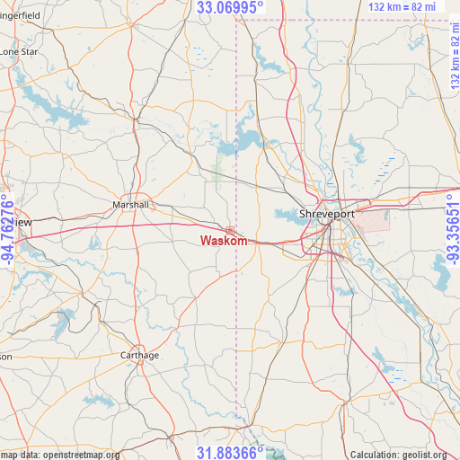
Waskom GPS coordinates[2]
32° 28' 43.536" North, 94° 3' 34.668" West
| Map corner | latitude | longitude |
|---|---|---|
| Upper-left | 33.06995°, | -94.76276° |
| Center: | 32.47876°, | -94.05963° |
| Lower-right: | 31.88366°, | -93.35651° |
| Map W x H: | 131.9×131.9 km | = 82×82mi |
| max Lat: | 71.29058° ⇑87.2% North |
| Waskom: | 32.47876° |
| min Lat: | ⇓12.8% South 19.06759° |
| min Long | Waskom | max Long |
| -171.73463° | -94.05963° | -66.98998° |
| W 31.2%⇐ | ⇒68.8% E |
Elevation
Elevation of Waskom is 89 m = 292 ft, and this is 205.8 m = 675 ft below average elevation for this country.
| Max E: |
3189 m = 10463 ft | 72% |
| Avg. | 294.8 m = 967 ft | |
| Waskom | 89 m = 292 ft | |
Min E: |
-60 m = -197 ft | 28% |
See also: United States elevation on elevation.city.
Geographical zone
Waskom is located in North temperate zone (between Tropic of Cancer and the Arctic Circle). Distance of this Northern Tropic circle is 1005.4 km =624.7 mi to South.| Distance of | km | miles | from Waskom |
|---|---|---|---|
| North Pole | 6395.8 | 3974.2 | to North |
| Arctic Circle | 3789.9 | 2354.9 | to North |
| Tropic Cancer | 1005.4 | 624.7 | to South |
| Equator | 3611.3 | 2244 | to South |


Nearby cities:
15 places around Waskom: (largest is in red/bold)
• Beckville
45.5 km =28.3 mi,  234°
234°
• Benton
38.3 km =23.8 mi,  51°
51°
• Blanchard
19.3 km =12 mi, 54°
• Bossier City
31 km =19.3 mi,  82°
82°
• Carthage
44.3 km =27.5 mi,  216°
216°
• Greenwood
9.1 km =5.7 mi,  116°
116°
• Jefferson
40.9 km =25.4 mi,  319°
319°
• Lakeview
22.2 km =13.8 mi, 77°
• Marshall
29.8 km =18.5 mi,  284°
284°
• Mooringsport
25 km =15.5 mi,  21°
21°
• Oil City
30.6 km =19 mi, 15°
• Red Chute
42.7 km =26.5 mi, 78°
• Shreveport
29.5 km =18.3 mi, 79°
• Stonewall
31.1 km =19.3 mi,  134°
134°
• Vivian
44.2 km =27.5 mi,  8°
8°
Sources, notices
• [Note1] Compared only with cities in United States existing in our database
• [Src1] Map data: © OpenStreetMap contributors (CC-BY-SA)
• [Src2] Other city data from geonames.org with taken over terms of usage.
• [Src3] Geographical zone / Annual Mean Temperature by Robert A. Rohde @ Wikipedia
