Plain Dealing geodata
Plain Dealing (Louisiana) is a populated place; located in United States in America/Chicago (GMT-5) time zone. With population of 969 people, there are 16499 cities with bigger population in this country. Compared to other cities in United States, 85.5% of cities are located further ↑North; 68% of cities are located further →East and 72.3% of cities have higher elevation than Plain Dealing. Note1


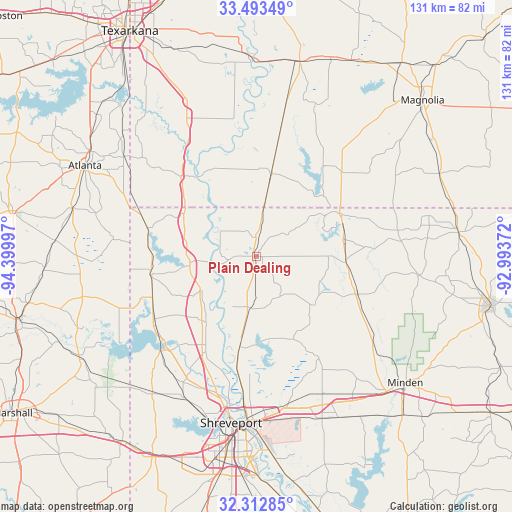
Plain Dealing GPS coordinates[2]
32° 54' 18.504" North, 93° 41' 48.624" West
| Map corner | latitude | longitude |
|---|---|---|
| Upper-left | 33.49349°, | -94.39997° |
| Center: | 32.90514°, | -93.69684° |
| Lower-right: | 32.31285°, | -92.99372° |
| Map W x H: | 131.3×131.3 km | = 81.6×81.6mi |
| max Lat: | 71.29058° ⇑85.5% North |
| Plain Dealing: | 32.90514° |
| min Lat: | ⇓14.5% South 19.06759° |
| min Long | Plain Dealing | max Long |
| -171.73463° | -93.69684° | -66.98998° |
| W 32%⇐ | ⇒68% E |
Elevation
Elevation of Plain Dealing is 87 m = 285 ft, and this is 207.8 m = 682 ft below average elevation for this country.
| Max E: |
3189 m = 10463 ft | 72.3% |
| Avg. | 294.8 m = 967 ft | |
| Plain Dealing | 87 m = 285 ft | |
Min E: |
-60 m = -197 ft | 27.7% |
See also: United States elevation on elevation.city.
Geographical zone
Plain Dealing is located in North temperate zone (between Tropic of Cancer and the Arctic Circle). Distance of this Northern Tropic circle is 1052.8 km =654.2 mi to South.| Distance of | km | miles | from Plain Dealing |
|---|---|---|---|
| North Pole | 6348.4 | 3944.7 | to North |
| Arctic Circle | 3742.5 | 2325.5 | to North |
| Tropic Cancer | 1052.8 | 654.2 | to South |
| Equator | 3658.7 | 2273.4 | to South |


Nearby cities:
15 places around Plain Dealing: (largest is in red/bold)
• Benton
23.8 km =14.8 mi,  190°
190°
• Blanchard
40.4 km =25.1 mi,  206°
206°
• Bradley
21.8 km =13.5 mi,  10°
10°
• Cotton Valley
27.8 km =17.3 mi,  110°
110°
• Cullen
24 km =14.9 mi,  72°
72°
• Eastwood
40.6 km =25.2 mi,  162°
162°
• Fouke
43.3 km =26.9 mi,  336°
336°
• Mooringsport
34.6 km =21.5 mi,  225°
225°
• Oil City
31.3 km =19.4 mi,  235°
235°
• Red Chute
39.6 km =24.6 mi,  168°
168°
• Sarepta
23.2 km =14.4 mi,  93°
93°
• Shreveport
42.5 km =26.4 mi, 186°
• Springhill
24.2 km =15 mi,  62°
62°
• Taylor
30.9 km =19.2 mi,  45°
45°
• Vivian
27.4 km =17 mi,  262°
262°
Sources, notices
• [Note1] Compared only with cities in United States existing in our database
• [Src1] Map data: © OpenStreetMap contributors (CC-BY-SA)
• [Src2] Other city data from geonames.org with taken over terms of usage.
• [Src3] Geographical zone / Annual Mean Temperature by Robert A. Rohde @ Wikipedia
