Bradley geodata
Bradley (Arkansas) is a populated place; located in United States in America/Chicago (GMT-5) time zone. With population of 566 people, there are 20074 cities with bigger population in this country. Compared to other cities in United States, 84.8% of cities are located further ↑North; 67.9% of cities are located further →East and 73.3% of cities have higher elevation than Bradley. Note1


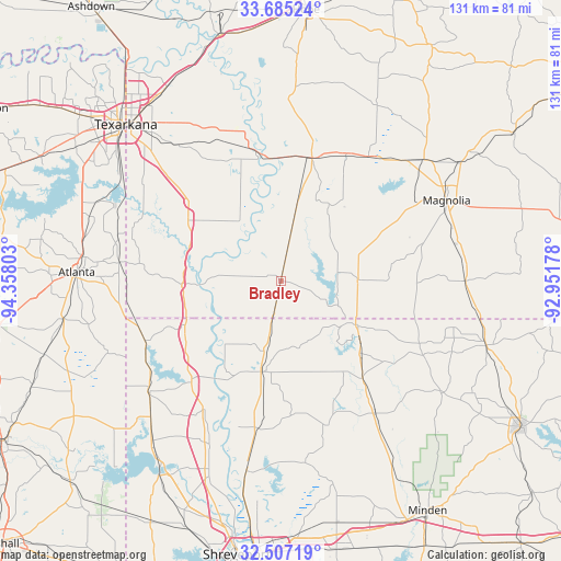
Bradley GPS coordinates[2]
33° 5' 53.484" North, 93° 39' 17.64" West
| Map corner | latitude | longitude |
|---|---|---|
| Upper-left | 33.68524°, | -94.35803° |
| Center: | 33.09819°, | -93.6549° |
| Lower-right: | 32.50719°, | -92.95178° |
| Map W x H: | 131×131 km | = 81.4×81.4mi |
| max Lat: | 71.29058° ⇑84.8% North |
| Bradley: | 33.09819° |
| min Lat: | ⇓15.2% South 19.06759° |
| min Long | Bradley | max Long |
| -171.73463° | -93.6549° | -66.98998° |
| W 32.1%⇐ | ⇒67.9% E |
Elevation
Elevation of Bradley is 81 m = 266 ft, and this is 213.8 m = 701 ft below average elevation for this country.
| Max E: |
3189 m = 10463 ft | 73.3% |
| Avg. | 294.8 m = 967 ft | |
| Bradley | 81 m = 266 ft | |
Min E: |
-60 m = -197 ft | 26.7% |
See also: United States elevation on elevation.city.
Geographical zone
Bradley is located in North temperate zone (between Tropic of Cancer and the Arctic Circle). Distance of this Northern Tropic circle is 1074.3 km =667.5 mi to South.| Distance of | km | miles | from Bradley |
|---|---|---|---|
| North Pole | 6326.9 | 3931.4 | to North |
| Arctic Circle | 3721 | 2312.1 | to North |
| Tropic Cancer | 1074.3 | 667.5 | to South |
| Equator | 3680.2 | 2286.8 | to South |


Nearby cities:
15 places around Bradley: (largest is in red/bold)
• Atlanta
47.5 km =29.5 mi,  272°
272°
• Benton
45.6 km =28.3 mi,  190°
190°
• Cotton Valley
38.1 km =23.7 mi,  144°
144°
• Cullen
23.8 km =14.8 mi,  127°
127°
• Fouke
28.1 km =17.5 mi,  310°
310°
• Lewisville
29.8 km =18.5 mi,  13°
13°
• Magnolia
43 km =26.7 mi,  64°
64°
• Plain Dealing
21.8 km =13.5 mi, 190°
• Queen City
46.5 km =28.9 mi,  276°
276°
• Sarepta
29.9 km =18.6 mi, 139°
• Springhill
20.3 km =12.6 mi,  120°
120°
• Stamps
33.2 km =20.6 mi,  26°
26°
• Taylor
18.1 km =11.2 mi,  89°
89°
• Vivian
40 km =24.9 mi,  230°
230°
• Waldo
43.7 km =27.2 mi,  49°
49°
Sources, notices
• [Note1] Compared only with cities in United States existing in our database
• [Src1] Map data: © OpenStreetMap contributors (CC-BY-SA)
• [Src2] Other city data from geonames.org with taken over terms of usage.
• [Src3] Geographical zone / Annual Mean Temperature by Robert A. Rohde @ Wikipedia
