Springfield geodata
Springfield (Missouri) is a seat of a second-order administrative division; located in United States in America/Chicago (GMT-5) time zone. With population of 166,810 people, there are 167 cities with bigger population in this country. Compared to other cities in United States, 65.2% of cities are located further ↑North; 67% of cities are located further →East and 83.7% of cities have lower elevation than Springfield. Note1
Administrative division(s):
- Level 1: Missouri
- Level 2: Greene County
- Level 3: Township of Springfield


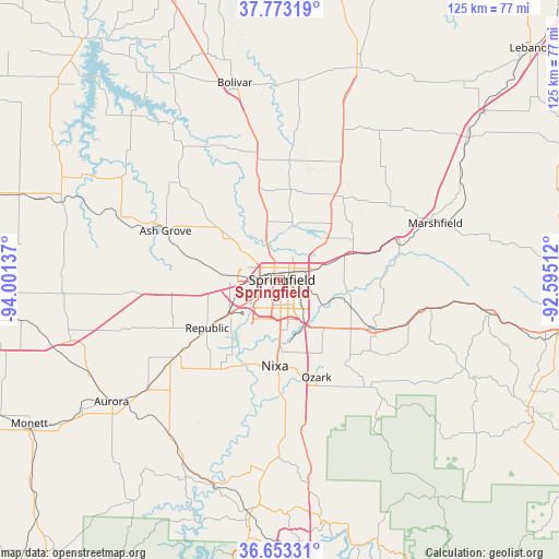
Springfield GPS coordinates[2]
37° 12' 55.188" North, 93° 17' 53.664" West
| Map corner | latitude | longitude |
|---|---|---|
| Upper-left | 37.77319°, | -94.00137° |
| Center: | 37.21533°, | -93.29824° |
| Lower-right: | 36.65331°, | -92.59512° |
| Map W x H: | 124.5×124.5 km | = 77.4×77.4mi |
| max Lat: | 71.29058° ⇑65.2% North |
| Springfield: | 37.21533° |
| min Lat: | ⇓34.8% South 19.06759° |
| min Long | Springfield | max Long |
| -171.73463° | -93.29824° | -66.98998° |
| W 33%⇐ | ⇒67% E |
Elevation
Elevation of Springfield is 399 m = 1309 ft, and this is 104.2 m = 342 ft above average elevation for this country.
| Max E: |
3189 m = 10463 ft | 16.3% |
| Springfield | 399 m 1309 ft | |
| Avg. | 294.8 m = 967 ft | |
Min E: |
-60 m = -197 ft | 83.7% |
See also: Springfield elevation on elevation.city.
Geographical zone
Springfield is located in North temperate zone (between Tropic of Cancer and the Arctic Circle). Distance of this Northern Tropic circle is 1532 km =951.9 mi to South.| Distance of | km | miles | from Springfield |
|---|---|---|---|
| North Pole | 5869.1 | 3646.9 | to North |
| Arctic Circle | 3263.2 | 2027.7 | to North |
| Tropic Cancer | 1532 | 951.9 | to South |
| Equator | 4138 | 2571.2 | to South |


Nearby cities:
15 places around Springfield: (largest is in red/bold)
• Ash Grove
27.7 km =17.2 mi,  293°
293°
• Battlefield
12.8 km =8 mi,  209°
209°
• Billings
27.9 km =17.3 mi,  233°
233°
• Clever
25.8 km =16 mi,  216°
216°
• Fair Grove
22.8 km =14.2 mi,  34°
34°
• Fremont Hills
17.3 km =10.7 mi,  165°
165°
• Nixa
19.1 km =11.9 mi,  178°
178°
• Ozark
23.1 km =14.4 mi,  159°
159°
• Pleasant Hope
27.6 km =17.1 mi,  4°
4°
• Republic
19.3 km =12 mi,  236°
236°
• Rogersville
24.1 km =15 mi,  116°
116°
• Sparta
30.6 km =19 mi,  141°
141°
• Strafford
17.1 km =10.6 mi,  69°
69°
• Walnut Grove
31.1 km =19.3 mi,  314°
314°
• Willard
15.2 km =9.4 mi, 310°
Sources, notices
• [Note1] Compared only with cities in United States existing in our database
• [Src1] Map data: © OpenStreetMap contributors (CC-BY-SA)
• [Src2] Other city data from geonames.org with taken over terms of usage.
• [Src3] Geographical zone / Annual Mean Temperature by Robert A. Rohde @ Wikipedia
