Flint Hill geodata
Flint Hill (Missouri) is a populated place; located in United States in America/Chicago (GMT-5) time zone. With population of 522 people, there are 20606 cities with bigger population in this country. Compared to other cities in United States, 56.1% of cities are located further ↑North; 61.8% of cities are located further →East and 58% of cities have higher elevation than Flint Hill. Note1
Administrative division(s):
- Level 1: Missouri
- Level 2: Saint Charles County
- Level 3: Township of Wentzville


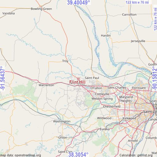
Flint Hill GPS coordinates[2]
38° 51' 18.18" North, 90° 51' 40.464" West
| Map corner | latitude | longitude |
|---|---|---|
| Upper-left | 39.40049°, | -91.56437° |
| Center: | 38.85505°, | -90.86124° |
| Lower-right: | 38.3054°, | -90.15812° |
| Map W x H: | 121.8×121.8 km | = 75.7×75.7mi |
| max Lat: | 71.29058° ⇑56.1% North |
| Flint Hill: | 38.85505° |
| min Lat: | ⇓43.9% South 19.06759° |
| min Long | Flint Hill | max Long |
| -171.73463° | -90.86124° | -66.98998° |
| W 38.2%⇐ | ⇒61.8% E |
Elevation
Elevation of Flint Hill is 165 m = 541 ft, and this is 129.8 m = 426 ft below average elevation for this country.
| Max E: |
3189 m = 10463 ft | 58% |
| Avg. | 294.8 m = 967 ft | |
| Flint Hill | 165 m = 541 ft | |
Min E: |
-60 m = -197 ft | 42% |
See also: United States elevation on elevation.city.
Geographical zone
Flint Hill is located in North temperate zone (between Tropic of Cancer and the Arctic Circle). Distance of this Northern Tropic circle is 1714.4 km =1065.3 mi to South.| Distance of | km | miles | from Flint Hill |
|---|---|---|---|
| North Pole | 5686.8 | 3533.6 | to North |
| Arctic Circle | 3080.9 | 1914.4 | to North |
| Tropic Cancer | 1714.4 | 1065.3 | to South |
| Equator | 4320.3 | 2684.5 | to South |


Nearby cities:
15 places around Flint Hill: (largest is in red/bold)
• Cottleville
21.7 km =13.5 mi,  123°
123°
• Dardenne Prairie
14.9 km =9.3 mi,  129°
129°
• Foristell
9.3 km =5.8 mi,  241°
241°
• Innsbrook
19.1 km =11.9 mi, 240°
• Lake Saint Louis
9.1 km =5.7 mi, 134°
• Moscow Mills
11.4 km =7.1 mi,  334°
334°
• O'Fallon
14.8 km =9.2 mi,  109°
109°
• Saint Paul
10.4 km =6.5 mi,  86°
86°
• Saint Peters
21.2 km =13.2 mi, 106°
• Troy
17.3 km =10.7 mi,  323°
323°
• Truesdale
23.8 km =14.8 mi,  258°
258°
• Weldon Spring
21.7 km =13.5 mi,  136°
136°
• Wentzville
4.9 km =3 mi,  171°
171°
• Winfield
19 km =11.8 mi,  33°
33°
• Wright City
14.1 km =8.8 mi, 257°
Sources, notices
• [Note1] Compared only with cities in United States existing in our database
• [Src1] Map data: © OpenStreetMap contributors (CC-BY-SA)
• [Src2] Other city data from geonames.org with taken over terms of usage.
• [Src3] Geographical zone / Annual Mean Temperature by Robert A. Rohde @ Wikipedia
