Lake Saint Louis geodata
Lake Saint Louis (Missouri) is a populated place; located in United States in America/Chicago (GMT-5) time zone. With population of 14,545 people, there are 3326 cities with bigger population in this country. Compared to other cities in United States, 56.6% of cities are located further ↑North; 61.6% of cities are located further →East and 57.1% of cities have higher elevation than Lake Saint Louis. Note1


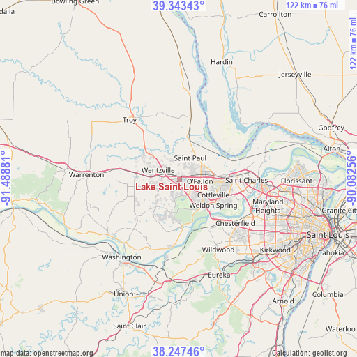
Lake Saint Louis GPS coordinates[2]
38° 47' 51.18" North, 90° 47' 8.448" West
| Map corner | latitude | longitude |
|---|---|---|
| Upper-left | 39.34343°, | -91.48881° |
| Center: | 38.79755°, | -90.78568° |
| Lower-right: | 38.24746°, | -90.08256° |
| Map W x H: | 121.9×121.9 km | = 75.7×75.7mi |
| max Lat: | 71.29058° ⇑56.6% North |
| Lake Saint Louis: | 38.79755° |
| min Lat: | ⇓43.4% South 19.06759° |
| min Long | Lake Saint Loui | max Long |
| -171.73463° | -90.78568° | -66.98998° |
| W 38.4%⇐ | ⇒61.6% E |
Elevation
Elevation of Lake Saint Louis is 170 m = 558 ft, and this is 124.8 m = 409 ft below average elevation for this country.
| Max E: |
3189 m = 10463 ft | 57.1% |
| Avg. | 294.8 m = 967 ft | |
| Lake Saint Louis | 170 m = 558 ft | |
Min E: |
-60 m = -197 ft | 42.9% |
See also: United States elevation on elevation.city.
Geographical zone
Lake Saint Louis is located in North temperate zone (between Tropic of Cancer and the Arctic Circle). Distance of this Northern Tropic circle is 1708 km =1061.3 mi to South.| Distance of | km | miles | from Lake Saint Louis |
|---|---|---|---|
| North Pole | 5693.2 | 3537.6 | to North |
| Arctic Circle | 3087.3 | 1918.4 | to North |
| Tropic Cancer | 1708 | 1061.3 | to South |
| Equator | 4313.9 | 2680.5 | to South |


Nearby cities:
15 places around Lake Saint Louis: (largest is in red/bold)
• Chesterfield
23.5 km =14.6 mi,  129°
129°
• Cottleville
12.8 km =8 mi,  116°
116°
• Dardenne Prairie
5.8 km =3.6 mi, 122°
• Flint Hill
9.1 km =5.7 mi,  314°
314°
• Foristell
14.9 km =9.3 mi,  277°
277°
• Innsbrook
23.3 km =14.5 mi,  262°
262°
• Moscow Mills
20.3 km =12.6 mi,  325°
325°
• O'Fallon
7.6 km =4.7 mi,  78°
78°
• Saint Paul
8.1 km =5 mi,  28°
28°
• Saint Peters
13.8 km =8.6 mi,  88°
88°
• Weldon Spring
12.5 km =7.8 mi,  138°
138°
• Wentzville
6 km =3.7 mi, 284°
• Wildwood
26.1 km =16.2 mi,  155°
155°
• Winfield
22.6 km =14 mi,  10°
10°
• Wright City
20.6 km =12.8 mi, 279°
Sources, notices
• [Note1] Compared only with cities in United States existing in our database
• [Src1] Map data: © OpenStreetMap contributors (CC-BY-SA)
• [Src2] Other city data from geonames.org with taken over terms of usage.
• [Src3] Geographical zone / Annual Mean Temperature by Robert A. Rohde @ Wikipedia
