Strafford geodata
Strafford (Missouri) is a populated place; located in United States in America/Chicago (GMT-5) time zone. With population of 2,361 people, there are 10949 cities with bigger population in this country. Compared to other cities in United States, 65% of cities are located further ↑North; 66.5% of cities are located further →East and 86.6% of cities have lower elevation than Strafford. Note1


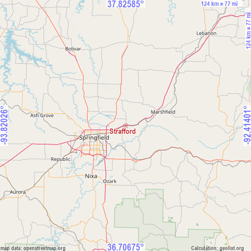
Strafford GPS coordinates[2]
37° 16' 6.168" North, 93° 7' 1.668" West
| Map corner | latitude | longitude |
|---|---|---|
| Upper-left | 37.82585°, | -93.82026° |
| Center: | 37.26838°, | -93.11713° |
| Lower-right: | 36.70675°, | -92.41401° |
| Map W x H: | 124.4×124.4 km | = 77.3×77.3mi |
| max Lat: | 71.29058° ⇑65% North |
| Strafford: | 37.26838° |
| min Lat: | ⇓35% South 19.06759° |
| min Long | Strafford | max Long |
| -171.73463° | -93.11713° | -66.98998° |
| W 33.5%⇐ | ⇒66.5% E |
Elevation
Elevation of Strafford is 455 m = 1493 ft, and this is 160.2 m = 526 ft above average elevation for this country.
| Max E: |
3189 m = 10463 ft | 13.4% |
| Strafford | 455 m 1493 ft | |
| Avg. | 294.8 m = 967 ft | |
Min E: |
-60 m = -197 ft | 86.6% |
See also: United States elevation on elevation.city.
Geographical zone
Strafford is located in North temperate zone (between Tropic of Cancer and the Arctic Circle). Distance of this Northern Tropic circle is 1537.9 km =955.6 mi to South.| Distance of | km | miles | from Strafford |
|---|---|---|---|
| North Pole | 5863.2 | 3643.2 | to North |
| Arctic Circle | 3257.3 | 2024 | to North |
| Tropic Cancer | 1537.9 | 955.6 | to South |
| Equator | 4143.9 | 2574.9 | to South |


Nearby cities:
15 places around Strafford: (largest is in red/bold)
• Battlefield
28.1 km =17.5 mi,  232°
232°
• Conway
36.9 km =22.9 mi,  45°
45°
• Fair Grove
13.2 km =8.2 mi,  346°
346°
• Fordland
19.9 km =12.4 mi,  128°
128°
• Fremont Hills
25.4 km =15.8 mi,  207°
207°
• Marshfield
20.2 km =12.6 mi,  67°
67°
• Nixa
29.5 km =18.3 mi, 212°
• Ozark
28.6 km =17.8 mi,  195°
195°
• Pleasant Hope
25.6 km =15.9 mi,  327°
327°
• Republic
36.1 km =22.4 mi,  242°
242°
• Rogersville
17.7 km =11 mi,  162°
162°
• Seymour
33.7 km =20.9 mi,  113°
113°
• Sparta
29.9 km =18.6 mi,  173°
173°
• Springfield
17.1 km =10.6 mi,  249°
249°
• Willard
27.8 km =17.3 mi,  278°
278°
Sources, notices
• [Note1] Compared only with cities in United States existing in our database
• [Src1] Map data: © OpenStreetMap contributors (CC-BY-SA)
• [Src2] Other city data from geonames.org with taken over terms of usage.
• [Src3] Geographical zone / Annual Mean Temperature by Robert A. Rohde @ Wikipedia
