Iuka geodata
Iuka (Mississippi) is a seat of a second-order administrative division; located in United States in America/Chicago (GMT-5) time zone. With population of 3,001 people, there are 9634 cities with bigger population in this country. Compared to other cities in United States, 76.3% of cities are located further ↑North; 53.7% of cities are located further →East and 56% of cities have higher elevation than Iuka. Note1


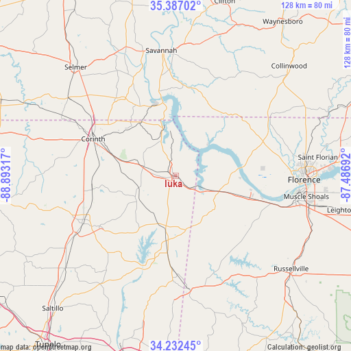
Iuka GPS coordinates[2]
34° 48' 42.336" North, 88° 11' 24.144" West
| Map corner | latitude | longitude |
|---|---|---|
| Upper-left | 35.38702°, | -88.89317° |
| Center: | 34.81176°, | -88.19004° |
| Lower-right: | 34.23245°, | -87.48692° |
| Map W x H: | 128.4×128.4 km | = 79.8×79.8mi |
| max Lat: | 71.29058° ⇑76.3% North |
| Iuka: | 34.81176° |
| min Lat: | ⇓23.7% South 19.06759° |
| min Long | Iuka | max Long |
| -171.73463° | -88.19004° | -66.98998° |
| W 46.3%⇐ | ⇒53.7% E |
Elevation
Elevation of Iuka is 176 m = 577 ft, and this is 118.8 m = 390 ft below average elevation for this country.
| Max E: |
3189 m = 10463 ft | 56% |
| Avg. | 294.8 m = 967 ft | |
| Iuka | 176 m = 577 ft | |
Min E: |
-60 m = -197 ft | 44% |
See also: United States elevation on elevation.city.
Geographical zone
Iuka is located in North temperate zone (between Tropic of Cancer and the Arctic Circle). Distance of this Northern Tropic circle is 1264.8 km =785.9 mi to South.| Distance of | km | miles | from Iuka |
|---|---|---|---|
| North Pole | 6136.4 | 3813 | to North |
| Arctic Circle | 3530.5 | 2193.8 | to North |
| Tropic Cancer | 1264.8 | 785.9 | to South |
| Equator | 3870.7 | 2405.1 | to South |


Nearby cities:
15 places around Iuka: (largest is in red/bold)
• Belmont
33.6 km =20.9 mi,  182°
182°
• Booneville
38.4 km =23.9 mi,  243°
243°
• Burnsville
11.8 km =7.3 mi,  285°
285°
• Cherokee
20.7 km =12.9 mi,  107°
107°
• Corinth
33.2 km =20.6 mi, 294°
• Eastview
43.7 km =27.2 mi,  312°
312°
• Farmington
27.3 km =17 mi,  298°
298°
• Florence
46.8 km =29.1 mi,  91°
91°
• Michie
35.2 km =21.9 mi,  320°
320°
• Olivet
44.8 km =27.8 mi,  358°
358°
• Red Bay
41.6 km =25.8 mi,  173°
173°
• Savannah
46.2 km =28.7 mi,  353°
353°
• Sheffield
45.2 km =28.1 mi,  96°
96°
• Tuscumbia
45.4 km =28.2 mi, 101°
• Underwood-Petersville
45.6 km =28.3 mi,  80°
80°
Sources, notices
• [Note1] Compared only with cities in United States existing in our database
• [Src1] Map data: © OpenStreetMap contributors (CC-BY-SA)
• [Src2] Other city data from geonames.org with taken over terms of usage.
• [Src3] Geographical zone / Annual Mean Temperature by Robert A. Rohde @ Wikipedia
