Youngsville geodata
Youngsville (North Carolina) is a populated place; located in United States in America/New_York (GMT-4) time zone. With population of 1,217 people, there are 15030 cities with bigger population in this country. Compared to other cities in United States, 70.3% of cities are located further ↑North; 76.9% of cities are located further ←West and 62.1% of cities have higher elevation than Youngsville. Note1
Administrative division(s):
- Level 1: North Carolina
- Level 2: Franklin County
- Level 3: Township of Youngsville


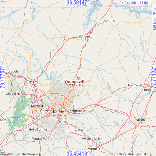
Youngsville GPS coordinates[2]
36° 1' 29.532" North, 78° 28' 27.984" West
| Map corner | latitude | longitude |
|---|---|---|
| Upper-left | 36.59147°, | -79.17757° |
| Center: | 36.02487°, | -78.47444° |
| Lower-right: | 35.45416°, | -77.77132° |
| Map W x H: | 126.5×126.5 km | = 78.6×78.6mi |
| max Lat: | 71.29058° ⇑70.3% North |
| Youngsville: | 36.02487° |
| min Lat: | ⇓29.7% South 19.06759° |
| min Long | Youngsville | max Long |
| -171.73463° | -78.47444° | -66.98998° |
| W 76.9%⇐ | ⇒23.1% E |
Elevation
Elevation of Youngsville is 144 m = 472 ft, and this is 150.8 m = 495 ft below average elevation for this country.
| Max E: |
3189 m = 10463 ft | 62.1% |
| Avg. | 294.8 m = 967 ft | |
| Youngsville | 144 m = 472 ft | |
Min E: |
-60 m = -197 ft | 37.9% |
See also: United States elevation on elevation.city.
Geographical zone
Youngsville is located in North temperate zone (between Tropic of Cancer and the Arctic Circle). Distance of this Northern Tropic circle is 1399.7 km =869.7 mi to South.| Distance of | km | miles | from Youngsville |
|---|---|---|---|
| North Pole | 6001.5 | 3729.2 | to North |
| Arctic Circle | 3395.6 | 2109.9 | to North |
| Tropic Cancer | 1399.7 | 869.7 | to South |
| Equator | 4005.6 | 2489 | to South |


Nearby cities:
15 places around Youngsville: (largest is in red/bold)
• Butner
28 km =17.4 mi,  295°
295°
• Creedmoor
21.9 km =13.6 mi, 299°
• Franklinton
8.7 km =5.4 mi,  9°
9°
• Gorman
31.4 km =19.5 mi,  272°
272°
• Knightdale
26.4 km =16.4 mi,  181°
181°
• Louisburg
17.6 km =10.9 mi,  62°
62°
• Oxford
33.5 km =20.8 mi,  341°
341°
• Raleigh
31.8 km =19.8 mi,  207°
207°
• Rolesville
11.4 km =7.1 mi,  172°
172°
• South Henderson
32.1 km =19.9 mi, 10°
• Spring Hope
33.8 km =21 mi,  105°
105°
• Wake Forest
5.9 km =3.7 mi, 212°
• Wendell
28.7 km =17.8 mi,  160°
160°
• West Raleigh
31.5 km =19.6 mi, 212°
• Zebulon
26.5 km =16.5 mi,  147°
147°
Sources, notices
• [Note1] Compared only with cities in United States existing in our database
• [Src1] Map data: © OpenStreetMap contributors (CC-BY-SA)
• [Src2] Other city data from geonames.org with taken over terms of usage.
• [Src3] Geographical zone / Annual Mean Temperature by Robert A. Rohde @ Wikipedia
