Jackson geodata
Jackson (Ohio) is a seat of a second-order administrative division; located in United States in America/New_York (GMT-4) time zone. With population of 6,243 people, there are 6244 cities with bigger population in this country. Compared to other cities in United States, 54.3% of cities are located further ↑North; 63.2% of cities are located further ←West and 53.9% of cities have lower elevation than Jackson. Note1


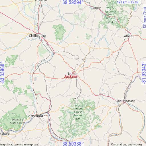
Jackson GPS coordinates[2]
39° 3' 7.272" North, 82° 38' 11.58" West
| Map corner | latitude | longitude |
|---|---|---|
| Upper-left | 39.59594°, | -83.33968° |
| Center: | 39.05202°, | -82.63655° |
| Lower-right: | 38.50388°, | -81.93343° |
| Map W x H: | 121.4×121.4 km | = 75.4×75.4mi |
| max Lat: | 71.29058° ⇑54.3% North |
| Jackson: | 39.05202° |
| min Lat: | ⇓45.7% South 19.06759° |
| min Long | Jackson | max Long |
| -171.73463° | -82.63655° | -66.98998° |
| W 63.2%⇐ | ⇒36.8% E |
Elevation
Elevation of Jackson is 214 m = 702 ft, and this is 80.8 m = 265 ft below average elevation for this country.
| Max E: |
3189 m = 10463 ft | 46.1% |
| Avg. | 294.8 m = 967 ft | |
| Jackson | 214 m = 702 ft | |
Min E: |
-60 m = -197 ft | 53.9% |
See also: United States elevation on elevation.city.
Geographical zone
Jackson is located in North temperate zone (between Tropic of Cancer and the Arctic Circle). Distance of this Northern Tropic circle is 1736.3 km =1078.9 mi to South.| Distance of | km | miles | from Jackson |
|---|---|---|---|
| North Pole | 5664.9 | 3520 | to North |
| Arctic Circle | 3059 | 1900.8 | to North |
| Tropic Cancer | 1736.3 | 1078.9 | to South |
| Equator | 4342.2 | 2698.1 | to South |


Nearby cities:
15 places around Jackson: (largest is in red/bold)
• Albany
42.2 km =26.2 mi,  62°
62°
• Clarktown
32.6 km =20.3 mi,  226°
226°
• Hamden
15.3 km =9.5 mi,  38°
38°
• Lucasville
36.6 km =22.7 mi,  238°
238°
• McArthur
25.6 km =15.9 mi,  32°
32°
• Minford
29 km =18 mi,  222°
222°
• Oak Hill
18.4 km =11.4 mi,  162°
162°
• Piketon
32.7 km =20.3 mi,  273°
273°
• Rio Grande
29.3 km =18.2 mi,  130°
130°
• Rosemount
41.9 km =26 mi, 225°
• Sciotodale
38.7 km =24 mi,  211°
211°
• South Webster
27.7 km =17.2 mi,  196°
196°
• Waverly
31.2 km =19.4 mi,  285°
285°
• Wellston
12 km =7.5 mi,  48°
48°
• Wheelersburg
40.5 km =25.2 mi, 207°
Sources, notices
• [Note1] Compared only with cities in United States existing in our database
• [Src1] Map data: © OpenStreetMap contributors (CC-BY-SA)
• [Src2] Other city data from geonames.org with taken over terms of usage.
• [Src3] Geographical zone / Annual Mean Temperature by Robert A. Rohde @ Wikipedia
