Seminole geodata
Seminole (Oklahoma) is a populated place; located in United States in America/Chicago (GMT-5) time zone. With population of 7,522 people, there are 5525 cities with bigger population in this country. Compared to other cities in United States, 74.2% of cities are located further ↑North; 74.9% of cities are located further →East and 67.8% of cities have lower elevation than Seminole. Note1


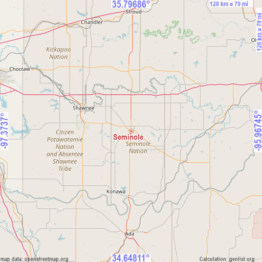
Seminole GPS coordinates[2]
35° 13' 28.272" North, 96° 40' 14.052" West
| Map corner | latitude | longitude |
|---|---|---|
| Upper-left | 35.79686°, | -97.3737° |
| Center: | 35.22452°, | -96.67057° |
| Lower-right: | 34.64811°, | -95.96745° |
| Map W x H: | 127.7×127.7 km | = 79.3×79.3mi |
| max Lat: | 71.29058° ⇑74.2% North |
| Seminole: | 35.22452° |
| min Lat: | ⇓25.8% South 19.06759° |
| min Long | Seminole | max Long |
| -171.73463° | -96.67057° | -66.98998° |
| W 25.1%⇐ | ⇒74.9% E |
Elevation
Elevation of Seminole is 275 m = 902 ft, and this is 19.8 m = 65 ft below average elevation for this country.
| Max E: |
3189 m = 10463 ft | 32.2% |
| Avg. | 294.8 m = 967 ft | |
| Seminole | 275 m = 902 ft | |
Min E: |
-60 m = -197 ft | 67.8% |
See also: United States elevation on elevation.city.
Geographical zone
Seminole is located in North temperate zone (between Tropic of Cancer and the Arctic Circle). Distance of this Northern Tropic circle is 1310.7 km =814.4 mi to South.| Distance of | km | miles | from Seminole |
|---|---|---|---|
| North Pole | 6090.5 | 3784.5 | to North |
| Arctic Circle | 3484.6 | 2165.2 | to North |
| Tropic Cancer | 1310.7 | 814.4 | to South |
| Equator | 3916.6 | 2433.7 | to South |


Nearby cities:
15 places around Seminole: (largest is in red/bold)
• Bethel Acres
33.6 km =20.9 mi,  286°
286°
• Boley
34.4 km =21.4 mi,  29°
29°
• Byng
40.4 km =25.1 mi,  179°
179°
• Earlsboro
13 km =8.1 mi, 291°
• Holdenville
29.4 km =18.3 mi,  123°
123°
• Konawa
30.4 km =18.9 mi,  194°
194°
• Maud
14.2 km =8.8 mi,  222°
222°
• Meeker
37.5 km =23.3 mi,  325°
325°
• Okemah
40.4 km =25.1 mi,  55°
55°
• Pink
41 km =25.5 mi,  275°
275°
• Prague
29.2 km =18.1 mi,  357°
357°
• Shawnee
25.8 km =16 mi,  296°
296°
• Tecumseh
24.4 km =15.2 mi, 278°
• Wetumka
39 km =24.2 mi,  87°
87°
• Wewoka
17.7 km =11 mi,  114°
114°
Sources, notices
• [Note1] Compared only with cities in United States existing in our database
• [Src1] Map data: © OpenStreetMap contributors (CC-BY-SA)
• [Src2] Other city data from geonames.org with taken over terms of usage.
• [Src3] Geographical zone / Annual Mean Temperature by Robert A. Rohde @ Wikipedia
