Blackwell geodata
Blackwell (Oklahoma) is a populated place; located in United States in America/Chicago (GMT-5) time zone. With population of 6,875 people, there are 5881 cities with bigger population in this country. Compared to other cities in United States, 66.9% of cities are located further ↑North; 76.5% of cities are located further →East and 75.4% of cities have lower elevation than Blackwell. Note1


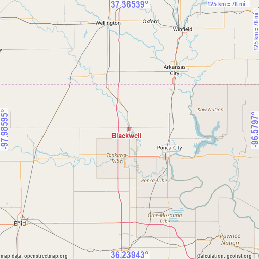
Blackwell GPS coordinates[2]
36° 48' 16.128" North, 97° 16' 58.152" West
| Map corner | latitude | longitude |
|---|---|---|
| Upper-left | 37.36539°, | -97.98595° |
| Center: | 36.80448°, | -97.28282° |
| Lower-right: | 36.23943°, | -96.5797° |
| Map W x H: | 125.2×125.2 km | = 77.8×77.8mi |
| max Lat: | 71.29058° ⇑66.9% North |
| Blackwell: | 36.80448° |
| min Lat: | ⇓33.1% South 19.06759° |
| min Long | Blackwell | max Long |
| -171.73463° | -97.28282° | -66.98998° |
| W 23.5%⇐ | ⇒76.5% E |
Elevation
Elevation of Blackwell is 316 m = 1037 ft, and this is 21.2 m = 70 ft above average elevation for this country.
| Max E: |
3189 m = 10463 ft | 24.6% |
| Blackwell | 316 m 1037 ft | |
| Avg. | 294.8 m = 967 ft | |
Min E: |
-60 m = -197 ft | 75.4% |
See also: United States elevation on elevation.city.
Geographical zone
Blackwell is located in North temperate zone (between Tropic of Cancer and the Arctic Circle). Distance of this Northern Tropic circle is 1486.4 km =923.6 mi to South.| Distance of | km | miles | from Blackwell |
|---|---|---|---|
| North Pole | 5914.8 | 3675.3 | to North |
| Arctic Circle | 3308.9 | 2056.1 | to North |
| Tropic Cancer | 1486.4 | 923.6 | to South |
| Equator | 4092.3 | 2542.8 | to South |


Nearby cities:
15 places around Blackwell: (largest is in red/bold)
• Arkansas City
35.9 km =22.3 mi,  37°
37°
• Billings
33.8 km =21 mi,  205°
205°
• Caldwell
38.4 km =23.9 mi,  311°
311°
• Fairfax
57.6 km =35.8 mi,  116°
116°
• Garber
49 km =30.4 mi, 213°
• McCord
25.8 km =16 mi, 122°
• Medford
40.1 km =24.9 mi,  270°
270°
• Newkirk
22.2 km =13.8 mi,  67°
67°
• Oxford
53.2 km =33.1 mi,  10°
10°
• Perry
57.3 km =35.6 mi,  180°
180°
• Ponca City
20.6 km =12.8 mi, 121°
• Pond Creek
48.6 km =30.2 mi,  251°
251°
• Tonkawa
14.2 km =8.8 mi,  189°
189°
• Wellington
51.8 km =32.2 mi,  351°
351°
• Winfield
54.7 km =34 mi,  27°
27°
Sources, notices
• [Note1] Compared only with cities in United States existing in our database
• [Src1] Map data: © OpenStreetMap contributors (CC-BY-SA)
• [Src2] Other city data from geonames.org with taken over terms of usage.
• [Src3] Geographical zone / Annual Mean Temperature by Robert A. Rohde @ Wikipedia
