Tipton geodata
Tipton (Oklahoma) is a populated place; located in United States in America/Chicago (GMT-5) time zone. With population of 794 people, there are 17869 cities with bigger population in this country. Compared to other cities in United States, 77.7% of cities are located further ↑North; 80% of cities are located further →East and 83.7% of cities have lower elevation than Tipton. Note1


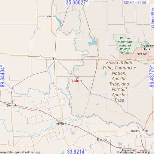
Tipton GPS coordinates[2]
34° 30' 10.26" North, 99° 8' 27.276" West
| Map corner | latitude | longitude |
|---|---|---|
| Upper-left | 35.08027°, | -99.84404° |
| Center: | 34.50285°, | -99.14091° |
| Lower-right: | 33.9214°, | -98.43779° |
| Map W x H: | 128.9×128.9 km | = 80.1×80.1mi |
| max Lat: | 71.29058° ⇑77.7% North |
| Tipton: | 34.50285° |
| min Lat: | ⇓22.3% South 19.06759° |
| min Long | Tipton | max Long |
| -171.73463° | -99.14091° | -66.98998° |
| W 20%⇐ | ⇒80% E |
Elevation
Elevation of Tipton is 400 m = 1312 ft, and this is 105.2 m = 345 ft above average elevation for this country.
| Max E: |
3189 m = 10463 ft | 16.3% |
| Tipton | 400 m 1312 ft | |
| Avg. | 294.8 m = 967 ft | |
Min E: |
-60 m = -197 ft | 83.7% |
See also: United States elevation on elevation.city.
Geographical zone
Tipton is located in North temperate zone (between Tropic of Cancer and the Arctic Circle). Distance of this Northern Tropic circle is 1230.4 km =764.5 mi to South.| Distance of | km | miles | from Tipton |
|---|---|---|---|
| North Pole | 6170.7 | 3834.3 | to North |
| Arctic Circle | 3564.8 | 2215.1 | to North |
| Tropic Cancer | 1230.4 | 764.5 | to South |
| Equator | 3836.4 | 2383.8 | to South |


Nearby cities:
15 places around Tipton: (largest is in red/bold)
• Altus
23.2 km =14.4 mi,  310°
310°
• Blair
35.5 km =22.1 mi,  329°
329°
• Burkburnett
69.1 km =42.9 mi,  130°
130°
• Cache
49 km =30.4 mi,  73°
73°
• Chillicothe
44 km =27.3 mi,  231°
231°
• Electra
56.5 km =35.1 mi,  158°
158°
• Frederick
16.7 km =10.4 mi,  137°
137°
• Grandfield
51.8 km =32.2 mi, 126°
• Granite
55.6 km =34.5 mi,  336°
336°
• Hobart
58.7 km =36.5 mi,  4°
4°
• Mangum
52.8 km =32.8 mi,  321°
321°
• Olustee
26.3 km =16.3 mi,  281°
281°
• Quanah
59.5 km =37 mi,  247°
247°
• Snyder
24.5 km =15.2 mi,  44°
44°
• Vernon
40.3 km =25 mi,  196°
196°
Sources, notices
• [Note1] Compared only with cities in United States existing in our database
• [Src1] Map data: © OpenStreetMap contributors (CC-BY-SA)
• [Src2] Other city data from geonames.org with taken over terms of usage.
• [Src3] Geographical zone / Annual Mean Temperature by Robert A. Rohde @ Wikipedia
