Altus geodata
Altus (Oklahoma) is a seat of a second-order administrative division; located in United States in America/Chicago (GMT-5) time zone. With population of 19,214 people, there are 2620 cities with bigger population in this country. Compared to other cities in United States, 77.1% of cities are located further ↑North; 80.2% of cities are located further →East and 85.3% of cities have lower elevation than Altus. Note1


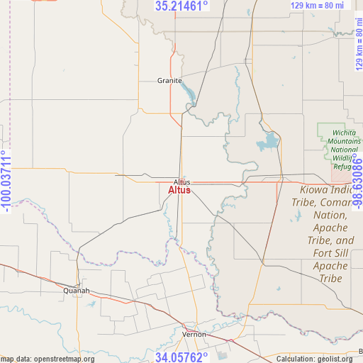
Altus GPS coordinates[2]
34° 38' 17.268" North, 99° 20' 2.328" West
| Map corner | latitude | longitude |
|---|---|---|
| Upper-left | 35.21461°, | -100.03711° |
| Center: | 34.63813°, | -99.33398° |
| Lower-right: | 34.05762°, | -98.63086° |
| Map W x H: | 128.6×128.6 km | = 79.9×79.9mi |
| max Lat: | 71.29058° ⇑77.1% North |
| Altus: | 34.63813° |
| min Lat: | ⇓22.9% South 19.06759° |
| min Long | Altus | max Long |
| -171.73463° | -99.33398° | -66.98998° |
| W 19.8%⇐ | ⇒80.2% E |
Elevation
Elevation of Altus is 430 m = 1411 ft, and this is 135.2 m = 444 ft above average elevation for this country.
| Max E: |
3189 m = 10463 ft | 14.7% |
| Altus | 430 m 1411 ft | |
| Avg. | 294.8 m = 967 ft | |
Min E: |
-60 m = -197 ft | 85.3% |
See also: United States elevation on elevation.city.
Geographical zone
Altus is located in North temperate zone (between Tropic of Cancer and the Arctic Circle). Distance of this Northern Tropic circle is 1245.5 km =773.9 mi to South.| Distance of | km | miles | from Altus |
|---|---|---|---|
| North Pole | 6155.7 | 3825 | to North |
| Arctic Circle | 3549.8 | 2205.7 | to North |
| Tropic Cancer | 1245.5 | 773.9 | to South |
| Equator | 3851.4 | 2393.1 | to South |


Nearby cities:
15 places around Altus: (largest is in red/bold)
• Blair
15.7 km =9.8 mi,  359°
359°
• Cache
64.5 km =40.1 mi,  90°
90°
• Chillicothe
45.6 km =28.3 mi,  201°
201°
• Dill City
73.3 km =45.5 mi,  14°
14°
• Frederick
39.8 km =24.7 mi,  133°
133°
• Granite
36.3 km =22.6 mi,  353°
353°
• Hobart
48.8 km =30.3 mi,  26°
26°
• Hollis
53.2 km =33.1 mi,  276°
276°
• Mangum
30.3 km =18.8 mi,  329°
329°
• Olustee
12.8 km =8 mi,  219°
219°
• Quanah
53.1 km =33 mi, 224°
• Sentinel
59.6 km =37 mi, 14°
• Snyder
35 km =21.7 mi, 86°
• Tipton
23.2 km =14.4 mi, 130°
• Vernon
54 km =33.6 mi,  173°
173°
Sources, notices
• [Note1] Compared only with cities in United States existing in our database
• [Src1] Map data: © OpenStreetMap contributors (CC-BY-SA)
• [Src2] Other city data from geonames.org with taken over terms of usage.
• [Src3] Geographical zone / Annual Mean Temperature by Robert A. Rohde @ Wikipedia
