Blair geodata
Blair (Oklahoma) is a populated place; located in United States in America/Chicago (GMT-5) time zone. With population of 778 people, there are 17996 cities with bigger population in this country. Compared to other cities in United States, 76.5% of cities are located further ↑North; 80.2% of cities are located further →East and 86.4% of cities have lower elevation than Blair. Note1


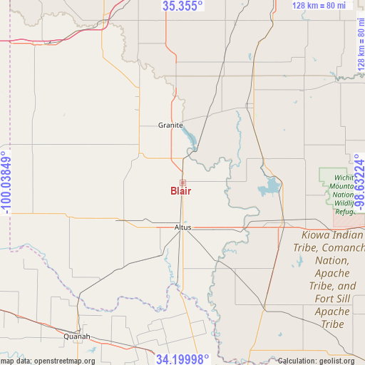
Blair GPS coordinates[2]
34° 46' 46.236" North, 99° 20' 7.296" West
| Map corner | latitude | longitude |
|---|---|---|
| Upper-left | 35.355°, | -100.03849° |
| Center: | 34.77951°, | -99.33536° |
| Lower-right: | 34.19998°, | -98.63224° |
| Map W x H: | 128.4×128.4 km | = 79.8×79.8mi |
| max Lat: | 71.29058° ⇑76.5% North |
| Blair: | 34.77951° |
| min Lat: | ⇓23.5% South 19.06759° |
| min Long | Blair | max Long |
| -171.73463° | -99.33536° | -66.98998° |
| W 19.8%⇐ | ⇒80.2% E |
Elevation
Elevation of Blair is 452 m = 1483 ft, and this is 157.2 m = 516 ft above average elevation for this country.
| Max E: |
3189 m = 10463 ft | 13.6% |
| Blair | 452 m 1483 ft | |
| Avg. | 294.8 m = 967 ft | |
Min E: |
-60 m = -197 ft | 86.4% |
See also: United States elevation on elevation.city.
Geographical zone
Blair is located in North temperate zone (between Tropic of Cancer and the Arctic Circle). Distance of this Northern Tropic circle is 1261.2 km =783.7 mi to South.| Distance of | km | miles | from Blair |
|---|---|---|---|
| North Pole | 6139.9 | 3815.2 | to North |
| Arctic Circle | 3534.1 | 2196 | to North |
| Tropic Cancer | 1261.2 | 783.7 | to South |
| Equator | 3867.1 | 2402.9 | to South |


Nearby cities:
15 places around Blair: (largest is in red/bold)
• Altus
15.7 km =9.8 mi,  179°
179°
• Chillicothe
60.5 km =37.6 mi,  195°
195°
• Cordell
65 km =40.4 mi,  29°
29°
• Dill City
58.2 km =36.2 mi,  18°
18°
• Frederick
51.9 km =32.2 mi,  146°
146°
• Granite
20.7 km =12.9 mi,  348°
348°
• Hobart
35.5 km =22.1 mi,  38°
38°
• Hollis
53.7 km =33.4 mi,  259°
259°
• Mangum
18.5 km =11.5 mi,  303°
303°
• Mountain View
64.3 km =40 mi,  56°
56°
• Olustee
26.9 km =16.7 mi, 197°
• Sayre
63.3 km =39.3 mi,  334°
334°
• Sentinel
44.5 km =27.7 mi, 19°
• Snyder
37.5 km =23.3 mi,  110°
110°
• Tipton
35.5 km =22.1 mi, 149°
Sources, notices
• [Note1] Compared only with cities in United States existing in our database
• [Src1] Map data: © OpenStreetMap contributors (CC-BY-SA)
• [Src2] Other city data from geonames.org with taken over terms of usage.
• [Src3] Geographical zone / Annual Mean Temperature by Robert A. Rohde @ Wikipedia
