Mangum geodata
Mangum (Oklahoma) is a seat of a second-order administrative division; located in United States in America/Chicago (GMT-5) time zone. With population of 2,910 people, there are 9783 cities with bigger population in this country. Compared to other cities in United States, 76% of cities are located further ↑North; 80.4% of cities are located further →East and 87.7% of cities have lower elevation than Mangum. Note1


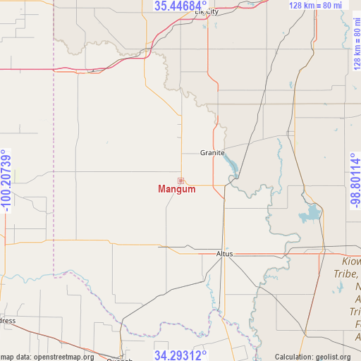
Mangum GPS coordinates[2]
34° 52' 19.2" North, 99° 30' 15.336" West
| Map corner | latitude | longitude |
|---|---|---|
| Upper-left | 35.44684°, | -100.20739° |
| Center: | 34.872°, | -99.50426° |
| Lower-right: | 34.29312°, | -98.80114° |
| Map W x H: | 128.3×128.3 km | = 79.7×79.7mi |
| max Lat: | 71.29058° ⇑76% North |
| Mangum: | 34.872° |
| min Lat: | ⇓24% South 19.06759° |
| min Long | Mangum | max Long |
| -171.73463° | -99.50426° | -66.98998° |
| W 19.6%⇐ | ⇒80.4% E |
Elevation
Elevation of Mangum is 492 m = 1614 ft, and this is 197.2 m = 647 ft above average elevation for this country.
| Max E: |
3189 m = 10463 ft | 12.3% |
| Mangum | 492 m 1614 ft | |
| Avg. | 294.8 m = 967 ft | |
Min E: |
-60 m = -197 ft | 87.7% |
See also: United States elevation on elevation.city.
Geographical zone
Mangum is located in North temperate zone (between Tropic of Cancer and the Arctic Circle). Distance of this Northern Tropic circle is 1271.5 km =790.1 mi to South.| Distance of | km | miles | from Mangum |
|---|---|---|---|
| North Pole | 6129.7 | 3808.8 | to North |
| Arctic Circle | 3523.8 | 2189.6 | to North |
| Tropic Cancer | 1271.5 | 790.1 | to South |
| Equator | 3877.4 | 2409.3 | to South |


Nearby cities:
15 places around Mangum: (largest is in red/bold)
• Altus
30.3 km =18.8 mi,  149°
149°
• Blair
18.5 km =11.5 mi,  123°
123°
• Burns Flat
61.1 km =38 mi,  29°
29°
• Canute
64.5 km =40.1 mi,  18°
18°
• Dill City
56.2 km =34.9 mi,  36°
36°
• Elk City
60.7 km =37.7 mi,  8°
8°
• Erick
50.4 km =31.3 mi,  319°
319°
• Granite
15.1 km =9.4 mi,  48°
48°
• Hobart
41.4 km =25.7 mi,  64°
64°
• Hollis
42.5 km =26.4 mi,  241°
241°
• Olustee
36.7 km =22.8 mi,  168°
168°
• Sayre
48.2 km =30 mi,  345°
345°
• Sentinel
43.7 km =27.2 mi, 43°
• Snyder
55.8 km =34.7 mi, 115°
• Tipton
52.8 km =32.8 mi,  141°
141°
Sources, notices
• [Note1] Compared only with cities in United States existing in our database
• [Src1] Map data: © OpenStreetMap contributors (CC-BY-SA)
• [Src2] Other city data from geonames.org with taken over terms of usage.
• [Src3] Geographical zone / Annual Mean Temperature by Robert A. Rohde @ Wikipedia
