Medford geodata
Medford (Oklahoma) is a seat of a second-order administrative division; located in United States in America/Chicago (GMT-5) time zone. With population of 987 people, there are 16366 cities with bigger population in this country. Compared to other cities in United States, 66.9% of cities are located further ↑North; 77.8% of cities are located further →East and 78.3% of cities have lower elevation than Medford. Note1


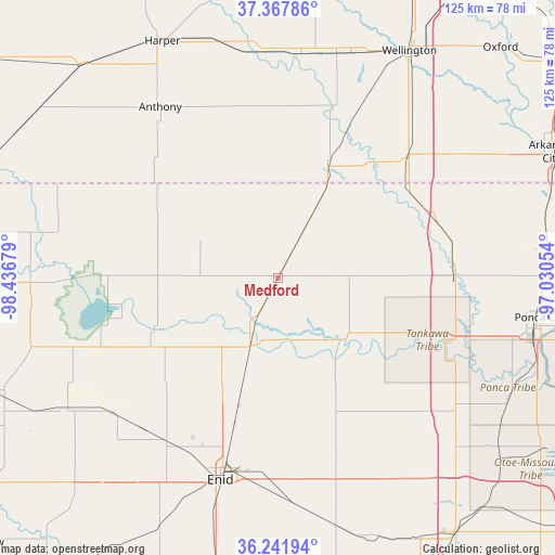
Medford GPS coordinates[2]
36° 48' 25.092" North, 97° 44' 1.176" West
| Map corner | latitude | longitude |
|---|---|---|
| Upper-left | 37.36786°, | -98.43679° |
| Center: | 36.80697°, | -97.73366° |
| Lower-right: | 36.24194°, | -97.03054° |
| Map W x H: | 125.2×125.2 km | = 77.8×77.8mi |
| max Lat: | 71.29058° ⇑66.9% North |
| Medford: | 36.80697° |
| min Lat: | ⇓33.1% South 19.06759° |
| min Long | Medford | max Long |
| -171.73463° | -97.73366° | -66.98998° |
| W 22.2%⇐ | ⇒77.8% E |
Elevation
Elevation of Medford is 338 m = 1109 ft, and this is 43.2 m = 142 ft above average elevation for this country.
| Max E: |
3189 m = 10463 ft | 21.7% |
| Medford | 338 m 1109 ft | |
| Avg. | 294.8 m = 967 ft | |
Min E: |
-60 m = -197 ft | 78.3% |
See also: United States elevation on elevation.city.
Geographical zone
Medford is located in North temperate zone (between Tropic of Cancer and the Arctic Circle). Distance of this Northern Tropic circle is 1486.6 km =923.7 mi to South.| Distance of | km | miles | from Medford |
|---|---|---|---|
| North Pole | 5914.5 | 3675.1 | to North |
| Arctic Circle | 3308.6 | 2055.9 | to North |
| Tropic Cancer | 1486.6 | 923.7 | to South |
| Equator | 4092.6 | 2543 | to South |


Nearby cities:
15 places around Medford: (largest is in red/bold)
• Anthony
46.7 km =29 mi,  325°
325°
• Billings
40.3 km =25 mi,  140°
140°
• Blackwell
40.1 km =24.9 mi,  90°
90°
• Caldwell
27.5 km =17.1 mi,  24°
24°
• Cherokee
55.8 km =34.7 mi,  263°
263°
• Covington
57.1 km =35.5 mi,  166°
166°
• Enid
47.5 km =29.5 mi,  195°
195°
• Garber
43.2 km =26.8 mi,  162°
162°
• Harper
59.3 km =36.8 mi, 334°
• Helena
55.9 km =34.7 mi,  238°
238°
• Lahoma
56.4 km =35 mi,  214°
214°
• North Enid
43 km =26.7 mi, 196°
• Ponca City
58.8 km =36.5 mi,  100°
100°
• Pond Creek
16.5 km =10.3 mi, 201°
• Tonkawa
40.4 km =25.1 mi,  110°
110°
Sources, notices
• [Note1] Compared only with cities in United States existing in our database
• [Src1] Map data: © OpenStreetMap contributors (CC-BY-SA)
• [Src2] Other city data from geonames.org with taken over terms of usage.
• [Src3] Geographical zone / Annual Mean Temperature by Robert A. Rohde @ Wikipedia
