Garber geodata
Garber (Oklahoma) is a populated place; located in United States in America/Chicago (GMT-5) time zone. With population of 852 people, there are 17346 cities with bigger population in this country. Compared to other cities in United States, 68.3% of cities are located further ↑North; 77.4% of cities are located further →East and 80.9% of cities have lower elevation than Garber. Note1


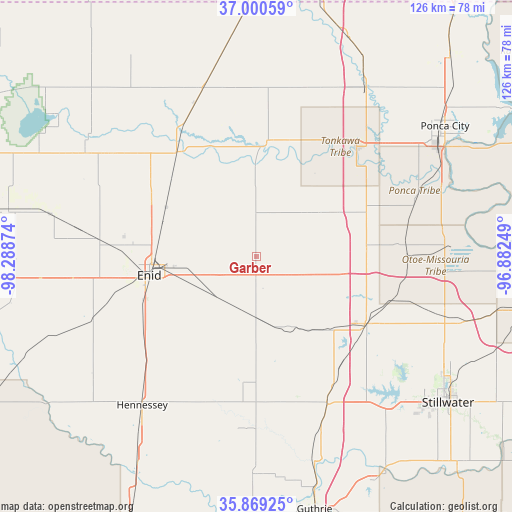
Garber GPS coordinates[2]
36° 26' 13.128" North, 97° 35' 8.196" West
| Map corner | latitude | longitude |
|---|---|---|
| Upper-left | 37.00059°, | -98.28874° |
| Center: | 36.43698°, | -97.58561° |
| Lower-right: | 35.86925°, | -96.88249° |
| Map W x H: | 125.8×125.8 km | = 78.2×78.2mi |
| max Lat: | 71.29058° ⇑68.3% North |
| Garber: | 36.43698° |
| min Lat: | ⇓31.7% South 19.06759° |
| min Long | Garber | max Long |
| -171.73463° | -97.58561° | -66.98998° |
| W 22.6%⇐ | ⇒77.4% E |
Elevation
Elevation of Garber is 364 m = 1194 ft, and this is 69.2 m = 227 ft above average elevation for this country.
| Max E: |
3189 m = 10463 ft | 19.1% |
| Garber | 364 m 1194 ft | |
| Avg. | 294.8 m = 967 ft | |
Min E: |
-60 m = -197 ft | 80.9% |
See also: United States elevation on elevation.city.
Geographical zone
Garber is located in North temperate zone (between Tropic of Cancer and the Arctic Circle). Distance of this Northern Tropic circle is 1445.5 km =898.2 mi to South.| Distance of | km | miles | from Garber |
|---|---|---|---|
| North Pole | 5955.6 | 3700.6 | to North |
| Arctic Circle | 3349.8 | 2081.5 | to North |
| Tropic Cancer | 1445.5 | 898.2 | to South |
| Equator | 4051.4 | 2517.4 | to South |


Nearby cities:
15 places around Garber: (largest is in red/bold)
• Billings
16.3 km =10.1 mi,  51°
51°
• Blackwell
49 km =30.4 mi,  33°
33°
• Covington
14.4 km =8.9 mi,  180°
180°
• Crescent
53.9 km =33.5 mi, 180°
• Enid
26.6 km =16.5 mi,  260°
260°
• Hennessey
46 km =28.6 mi,  217°
217°
• Lahoma
45.4 km =28.2 mi, 263°
• Medford
43.2 km =26.8 mi,  342°
342°
• Morrison
54 km =33.6 mi,  106°
106°
• North Enid
25.3 km =15.7 mi,  269°
269°
• Perry
31.3 km =19.4 mi,  121°
121°
• Ponca City
53.8 km =33.4 mi,  56°
56°
• Pond Creek
32.2 km =20 mi,  323°
323°
• Tonkawa
36.4 km =22.6 mi,  42°
42°
• Waukomis
33 km =20.5 mi,  238°
238°
Sources, notices
• [Note1] Compared only with cities in United States existing in our database
• [Src1] Map data: © OpenStreetMap contributors (CC-BY-SA)
• [Src2] Other city data from geonames.org with taken over terms of usage.
• [Src3] Geographical zone / Annual Mean Temperature by Robert A. Rohde @ Wikipedia
