Enid geodata
Enid (Oklahoma) is a seat of a second-order administrative division; located in United States in America/Chicago (GMT-5) time zone. With population of 51,776 people, there are 912 cities with bigger population in this country. Compared to other cities in United States, 68.5% of cities are located further ↑North; 78.2% of cities are located further →East and 82.9% of cities have lower elevation than Enid. Note1


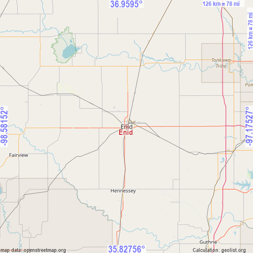
Enid GPS coordinates[2]
36° 23' 44.124" North, 97° 52' 42.204" West
| Map corner | latitude | longitude |
|---|---|---|
| Upper-left | 36.9595°, | -98.58152° |
| Center: | 36.39559°, | -97.87839° |
| Lower-right: | 35.82756°, | -97.17527° |
| Map W x H: | 125.9×125.9 km | = 78.2×78.2mi |
| max Lat: | 71.29058° ⇑68.5% North |
| Enid: | 36.39559° |
| min Lat: | ⇓31.5% South 19.06759° |
| min Long | Enid | max Long |
| -171.73463° | -97.87839° | -66.98998° |
| W 21.8%⇐ | ⇒78.2% E |
Elevation
Elevation of Enid is 388 m = 1273 ft, and this is 93.2 m = 306 ft above average elevation for this country.
| Max E: |
3189 m = 10463 ft | 17.1% |
| Enid | 388 m 1273 ft | |
| Avg. | 294.8 m = 967 ft | |
Min E: |
-60 m = -197 ft | 82.9% |
See also: Enid elevation on elevation.city.
Geographical zone
Enid is located in North temperate zone (between Tropic of Cancer and the Arctic Circle). Distance of this Northern Tropic circle is 1440.9 km =895.3 mi to South.| Distance of | km | miles | from Enid |
|---|---|---|---|
| North Pole | 5960.3 | 3703.6 | to North |
| Arctic Circle | 3354.4 | 2084.3 | to North |
| Tropic Cancer | 1440.9 | 895.3 | to South |
| Equator | 4046.8 | 2514.6 | to South |


Nearby cities:
15 places around Enid: (largest is in red/bold)
• Billings
41.6 km =25.8 mi,  69°
69°
• Covington
27.9 km =17.3 mi,  110°
110°
• Crescent
55.5 km =34.5 mi,  152°
152°
• Fairview
55.7 km =34.6 mi,  255°
255°
• Garber
26.6 km =16.5 mi,  80°
80°
• Helena
38.8 km =24.1 mi,  295°
295°
• Hennessey
31.9 km =19.8 mi,  183°
183°
• Lahoma
18.9 km =11.7 mi,  267°
267°
• Medford
47.5 km =29.5 mi,  15°
15°
• North Enid
4.5 km =2.8 mi,  10°
10°
• Okeene
50.1 km =31.1 mi,  231°
231°
• Perry
54.2 km =33.7 mi,  102°
102°
• Pond Creek
31.2 km =19.4 mi, 12°
• Ringwood
32.9 km =20.4 mi, 266°
• Waukomis
12.9 km =8 mi,  187°
187°
Sources, notices
• [Note1] Compared only with cities in United States existing in our database
• [Src1] Map data: © OpenStreetMap contributors (CC-BY-SA)
• [Src2] Other city data from geonames.org with taken over terms of usage.
• [Src3] Geographical zone / Annual Mean Temperature by Robert A. Rohde @ Wikipedia
