Caldwell geodata
Caldwell (Kansas) is a populated place; located in United States in America/Chicago (GMT-5) time zone. With population of 1,030 people, there are 16079 cities with bigger population in this country. Compared to other cities in United States, 66% of cities are located further ↑North; 77.5% of cities are located further →East and 80.3% of cities have lower elevation than Caldwell. Note1


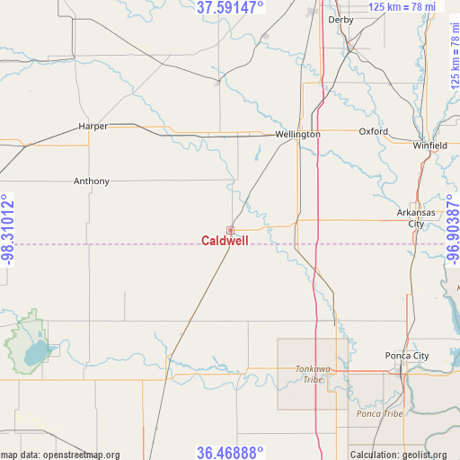
Caldwell GPS coordinates[2]
37° 1' 56.1" North, 97° 36' 25.164" West
| Map corner | latitude | longitude |
|---|---|---|
| Upper-left | 37.59147°, | -98.31012° |
| Center: | 37.03225°, | -97.60699° |
| Lower-right: | 36.46888°, | -96.90387° |
| Map W x H: | 124.8×124.8 km | = 77.5×77.5mi |
| max Lat: | 71.29058° ⇑66% North |
| Caldwell: | 37.03225° |
| min Lat: | ⇓34% South 19.06759° |
| min Long | Caldwell | max Long |
| -171.73463° | -97.60699° | -66.98998° |
| W 22.5%⇐ | ⇒77.5% E |
Elevation
Elevation of Caldwell is 356 m = 1168 ft, and this is 61.2 m = 201 ft above average elevation for this country.
| Max E: |
3189 m = 10463 ft | 19.7% |
| Caldwell | 356 m 1168 ft | |
| Avg. | 294.8 m = 967 ft | |
Min E: |
-60 m = -197 ft | 80.3% |
See also: United States elevation on elevation.city.
Geographical zone
Caldwell is located in North temperate zone (between Tropic of Cancer and the Arctic Circle). Distance of this Northern Tropic circle is 1511.7 km =939.3 mi to South.| Distance of | km | miles | from Caldwell |
|---|---|---|---|
| North Pole | 5889.5 | 3659.6 | to North |
| Arctic Circle | 3283.6 | 2040.3 | to North |
| Tropic Cancer | 1511.7 | 939.3 | to South |
| Equator | 4117.6 | 2558.6 | to South |


Nearby cities:
15 places around Caldwell: (largest is in red/bold)
• Anthony
40 km =24.9 mi,  289°
289°
• Arkansas City
50.6 km =31.4 mi,  86°
86°
• Belle Plaine
49.5 km =30.8 mi,  35°
35°
• Billings
57.8 km =35.9 mi,  165°
165°
• Blackwell
38.4 km =23.9 mi,  131°
131°
• Clearwater
53.1 km =33 mi,  9°
9°
• Conway Springs
39.9 km =24.8 mi,  355°
355°
• Harper
46.7 km =29 mi,  307°
307°
• Medford
27.5 km =17.1 mi,  204°
204°
• Mulvane
58.7 km =36.5 mi,  33°
33°
• Newkirk
51.9 km =32.2 mi,  108°
108°
• Oxford
47.2 km =29.3 mi,  55°
55°
• Pond Creek
43.9 km =27.3 mi, 203°
• Tonkawa
47.4 km =29.5 mi,  146°
146°
• Wellington
33.3 km =20.7 mi, 38°
Sources, notices
• [Note1] Compared only with cities in United States existing in our database
• [Src1] Map data: © OpenStreetMap contributors (CC-BY-SA)
• [Src2] Other city data from geonames.org with taken over terms of usage.
• [Src3] Geographical zone / Annual Mean Temperature by Robert A. Rohde @ Wikipedia
