Holdenville geodata
Holdenville (Oklahoma) is a seat of a second-order administrative division; located in United States in America/Chicago (GMT-5) time zone. With population of 5,750 people, there are 6572 cities with bigger population in this country. Compared to other cities in United States, 74.9% of cities are located further ↑North; 74.2% of cities are located further →East and 66.1% of cities have lower elevation than Holdenville. Note1


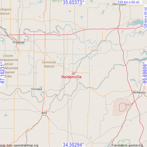
Holdenville GPS coordinates[2]
35° 4' 49.296" North, 96° 23' 57.048" West
| Map corner | latitude | longitude |
|---|---|---|
| Upper-left | 35.65373°, | -97.10231° |
| Center: | 35.08036°, | -96.39918° |
| Lower-right: | 34.50294°, | -95.69606° |
| Map W x H: | 128×128 km | = 79.5×79.5mi |
| max Lat: | 71.29058° ⇑74.9% North |
| Holdenville: | 35.08036° |
| min Lat: | ⇓25.1% South 19.06759° |
| min Long | Holdenville | max Long |
| -171.73463° | -96.39918° | -66.98998° |
| W 25.8%⇐ | ⇒74.2% E |
Elevation
Elevation of Holdenville is 267 m = 876 ft, and this is 27.8 m = 91 ft below average elevation for this country.
| Max E: |
3189 m = 10463 ft | 33.9% |
| Avg. | 294.8 m = 967 ft | |
| Holdenville | 267 m = 876 ft | |
Min E: |
-60 m = -197 ft | 66.1% |
See also: United States elevation on elevation.city.
Geographical zone
Holdenville is located in North temperate zone (between Tropic of Cancer and the Arctic Circle). Distance of this Northern Tropic circle is 1294.7 km =804.5 mi to South.| Distance of | km | miles | from Holdenville |
|---|---|---|---|
| North Pole | 6106.5 | 3794.4 | to North |
| Arctic Circle | 3500.6 | 2175.2 | to North |
| Tropic Cancer | 1294.7 | 804.5 | to South |
| Equator | 3900.6 | 2423.7 | to South |


Nearby cities:
15 places around Holdenville: (largest is in red/bold)
• Ada
42.5 km =26.4 mi,  216°
216°
• Allen
22.4 km =13.9 mi,  183°
183°
• Boley
46.6 km =29 mi,  350°
350°
• Byng
34.4 km =21.4 mi, 224°
• Earlsboro
42.2 km =26.2 mi,  299°
299°
• Henryetta
55.1 km =34.2 mi,  43°
43°
• Konawa
34.9 km =21.7 mi,  247°
247°
• Maud
34.7 km =21.6 mi,  279°
279°
• Okemah
40.1 km =24.9 mi,  12°
12°
• Prague
52.1 km =32.4 mi,  330°
330°
• Seminole
29.4 km =18.3 mi, 303°
• Tecumseh
52.7 km =32.7 mi,  291°
291°
• Weleetka
37.1 km =23.1 mi, 40°
• Wetumka
22.6 km =14 mi, 39°
• Wewoka
12.2 km =7.6 mi,  315°
315°
Sources, notices
• [Note1] Compared only with cities in United States existing in our database
• [Src1] Map data: © OpenStreetMap contributors (CC-BY-SA)
• [Src2] Other city data from geonames.org with taken over terms of usage.
• [Src3] Geographical zone / Annual Mean Temperature by Robert A. Rohde @ Wikipedia
