Centerville geodata
Centerville (Tennessee) is a seat of a second-order administrative division; located in United States in America/Chicago (GMT-5) time zone. With population of 3,584 people, there are 8744 cities with bigger population in this country. Compared to other cities in United States, 71.4% of cities are located further ↑North; 50.7% of cities are located further →East and 51.6% of cities have higher elevation than Centerville. Note1


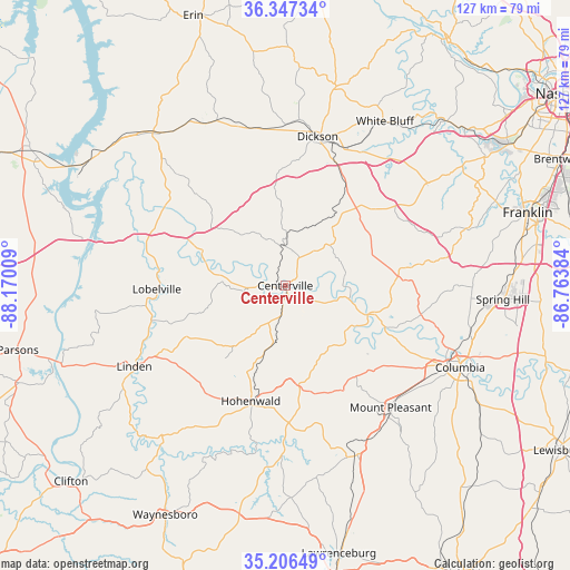
Centerville GPS coordinates[2]
35° 46' 44.256" North, 87° 28' 1.056" West
| Map corner | latitude | longitude |
|---|---|---|
| Upper-left | 36.34734°, | -88.17009° |
| Center: | 35.77896°, | -87.46696° |
| Lower-right: | 35.20649°, | -86.76384° |
| Map W x H: | 126.9×126.9 km | = 78.9×78.9mi |
| max Lat: | 71.29058° ⇑71.4% North |
| Centerville: | 35.77896° |
| min Lat: | ⇓28.6% South 19.06759° |
| min Long | Centerville | max Long |
| -171.73463° | -87.46696° | -66.98998° |
| W 49.3%⇐ | ⇒50.7% E |
Elevation
Elevation of Centerville is 192 m = 630 ft, and this is 102.8 m = 337 ft below average elevation for this country.
| Max E: |
3189 m = 10463 ft | 51.6% |
| Avg. | 294.8 m = 967 ft | |
| Centerville | 192 m = 630 ft | |
Min E: |
-60 m = -197 ft | 48.4% |
See also: United States elevation on elevation.city.
Geographical zone
Centerville is located in North temperate zone (between Tropic of Cancer and the Arctic Circle). Distance of this Northern Tropic circle is 1372.3 km =852.7 mi to South.| Distance of | km | miles | from Centerville |
|---|---|---|---|
| North Pole | 6028.8 | 3746.1 | to North |
| Arctic Circle | 3422.9 | 2126.9 | to North |
| Tropic Cancer | 1372.3 | 852.7 | to South |
| Equator | 3978.2 | 2471.9 | to South |


Nearby cities:
15 places around Centerville: (largest is in red/bold)
• Bon Aqua Junction
21.7 km =13.5 mi,  40°
40°
• Burns
33.5 km =20.8 mi,  24°
24°
• Charlotte
45.7 km =28.4 mi,  14°
14°
• Columbia
43 km =26.7 mi,  115°
115°
• Dickson
33.9 km =21.1 mi, 12°
• Fairview
38.5 km =23.9 mi,  54°
54°
• Hohenwald
26.8 km =16.7 mi,  196°
196°
• Linden
38.1 km =23.7 mi,  241°
241°
• Lobelville
28.6 km =17.8 mi,  268°
268°
• Lyles
19.1 km =11.9 mi, 35°
• McEwen
39.5 km =24.5 mi,  337°
337°
• Mount Pleasant
35.9 km =22.3 mi,  139°
139°
• Summertown
40.7 km =25.3 mi,  159°
159°
• Waverly
45 km =28 mi,  318°
318°
• White Bluff
42.7 km =26.5 mi,  31°
31°
Sources, notices
• [Note1] Compared only with cities in United States existing in our database
• [Src1] Map data: © OpenStreetMap contributors (CC-BY-SA)
• [Src2] Other city data from geonames.org with taken over terms of usage.
• [Src3] Geographical zone / Annual Mean Temperature by Robert A. Rohde @ Wikipedia
