Red Boiling Springs geodata
Red Boiling Springs (Tennessee) is a populated place; located in United States in America/Chicago (GMT-5) time zone. With population of 1,140 people, there are 15439 cities with bigger population in this country. Compared to other cities in United States, 67.9% of cities are located further ↑North; 53.3% of cities are located further ←West and 58.2% of cities have lower elevation than Red Boiling Springs. Note1


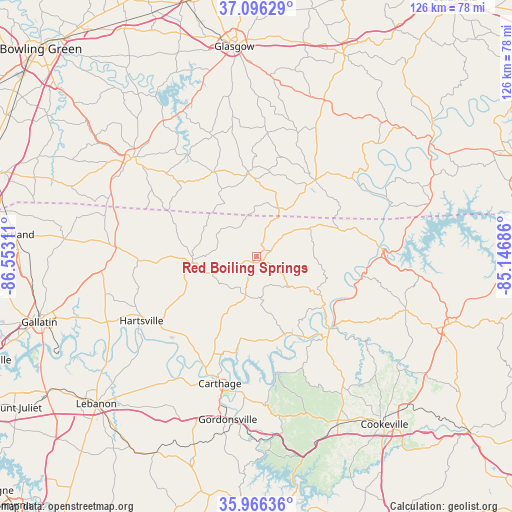
Red Boiling Springs GPS coordinates[2]
36° 32' 0.204" North, 85° 50' 59.928" West
| Map corner | latitude | longitude |
|---|---|---|
| Upper-left | 37.09629°, | -86.55311° |
| Center: | 36.53339°, | -85.84998° |
| Lower-right: | 35.96636°, | -85.14686° |
| Map W x H: | 125.6×125.6 km | = 78×78mi |
| max Lat: | 71.29058° ⇑67.9% North |
| Red Boiling Springs: | 36.53339° |
| min Lat: | ⇓32.1% South 19.06759° |
| min Long | Red Boiling Spr | max Long |
| -171.73463° | -85.84998° | -66.98998° |
| W 53.3%⇐ | ⇒46.7% E |
Elevation
Elevation of Red Boiling Springs is 231 m = 758 ft, and this is 63.8 m = 209 ft below average elevation for this country.
| Max E: |
3189 m = 10463 ft | 41.8% |
| Avg. | 294.8 m = 967 ft | |
| Red Boiling Springs | 231 m = 758 ft | |
Min E: |
-60 m = -197 ft | 58.2% |
See also: United States elevation on elevation.city.
Geographical zone
Red Boiling Springs is located in North temperate zone (between Tropic of Cancer and the Arctic Circle). Distance of this Northern Tropic circle is 1456.2 km =904.8 mi to South.| Distance of | km | miles | from Red Boiling Springs |
|---|---|---|---|
| North Pole | 5944.9 | 3694 | to North |
| Arctic Circle | 3339 | 2074.8 | to North |
| Tropic Cancer | 1456.2 | 904.8 | to South |
| Equator | 4062.1 | 2524.1 | to South |


Nearby cities:
15 places around Red Boiling Springs: (largest is in red/bold)
• Baxter
46.1 km =28.6 mi,  156°
156°
• Carthage
32.6 km =20.3 mi,  196°
196°
• Castalian Springs
43.8 km =27.2 mi,  249°
249°
• Celina
30.9 km =19.2 mi,  86°
86°
• Dodson Branch
37.6 km =23.4 mi,  130°
130°
• Gainesboro
26.1 km =16.2 mi,  139°
139°
• Gordonsville
40.8 km =25.4 mi,  190°
190°
• Hartsville
32.5 km =20.2 mi,  240°
240°
• Lafayette
15.8 km =9.8 mi,  265°
265°
• Lafayette
40.5 km =25.2 mi, 162°
• Livingston
50 km =31.1 mi,  109°
109°
• Scottsville
39 km =24.2 mi,  308°
308°
• South Carthage
33.7 km =20.9 mi, 195°
• Tompkinsville
23.5 km =14.6 mi,  36°
36°
• Westmoreland
35.7 km =22.2 mi,  275°
275°
Sources, notices
• [Note1] Compared only with cities in United States existing in our database
• [Src1] Map data: © OpenStreetMap contributors (CC-BY-SA)
• [Src2] Other city data from geonames.org with taken over terms of usage.
• [Src3] Geographical zone / Annual Mean Temperature by Robert A. Rohde @ Wikipedia
