Christiana geodata
Christiana (Tennessee) is a populated place; located in United States in America/Chicago (GMT-5) time zone. With population of 9,830 people, there are 4517 cities with bigger population in this country. Compared to other cities in United States, 71.7% of cities are located further ↑North; 51.8% of cities are located further ←West and 54.2% of cities have lower elevation than Christiana. Note1


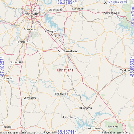
Christiana GPS coordinates[2]
35° 42' 36.252" North, 86° 23' 57.984" West
| Map corner | latitude | longitude |
|---|---|---|
| Upper-left | 36.27894°, | -87.10257° |
| Center: | 35.71007°, | -86.39944° |
| Lower-right: | 35.13711°, | -85.69632° |
| Map W x H: | 127×127 km | = 78.9×78.9mi |
| max Lat: | 71.29058° ⇑71.7% North |
| Christiana: | 35.71007° |
| min Lat: | ⇓28.3% South 19.06759° |
| min Long | Christiana | max Long |
| -171.73463° | -86.39944° | -66.98998° |
| W 51.8%⇐ | ⇒48.2% E |
Elevation
Elevation of Christiana is 215 m = 705 ft, and this is 79.8 m = 262 ft below average elevation for this country.
| Max E: |
3189 m = 10463 ft | 45.8% |
| Avg. | 294.8 m = 967 ft | |
| Christiana | 215 m = 705 ft | |
Min E: |
-60 m = -197 ft | 54.2% |
See also: United States elevation on elevation.city.
Geographical zone
Christiana is located in North temperate zone (between Tropic of Cancer and the Arctic Circle). Distance of this Northern Tropic circle is 1364.7 km =848 mi to South.| Distance of | km | miles | from Christiana |
|---|---|---|---|
| North Pole | 6036.5 | 3750.9 | to North |
| Arctic Circle | 3430.6 | 2131.7 | to North |
| Tropic Cancer | 1364.7 | 848 | to South |
| Equator | 3970.6 | 2467.2 | to South |


Nearby cities:
15 places around Christiana: (largest is in red/bold)
• Bell Buckle
13.8 km =8.6 mi,  162°
162°
• Chapel Hill
28.1 km =17.5 mi,  250°
250°
• Eagleville
22.9 km =14.2 mi,  278°
278°
• La Vergne
37.7 km =23.4 mi,  334°
334°
• Lakewood Park
24.8 km =15.4 mi,  105°
105°
• Manchester
37.9 km =23.5 mi,  132°
132°
• Murfreesboro
15.1 km =9.4 mi,  3°
3°
• New Union
34.9 km =21.7 mi,  124°
124°
• Nolensville
36.3 km =22.6 mi,  317°
317°
• Shelbyville
25.8 km =16 mi,  192°
192°
• Smyrna
32.2 km =20 mi,  340°
340°
• Tullahoma
42.3 km =26.3 mi, 156°
• Unionville
20 km =12.4 mi,  240°
240°
• Wartrace
21.2 km =13.2 mi, 163°
• Woodbury
32.3 km =20.1 mi,  66°
66°
Sources, notices
• [Note1] Compared only with cities in United States existing in our database
• [Src1] Map data: © OpenStreetMap contributors (CC-BY-SA)
• [Src2] Other city data from geonames.org with taken over terms of usage.
• [Src3] Geographical zone / Annual Mean Temperature by Robert A. Rohde @ Wikipedia
