Smyrna geodata
Smyrna (Tennessee) is a populated place; located in United States in America/Chicago (GMT-5) time zone. With population of 46,607 people, there are 1033 cities with bigger population in this country. Compared to other cities in United States, 70.5% of cities are located further ↑North; 51.5% of cities are located further ←West and 57.7% of cities have higher elevation than Smyrna. Note1


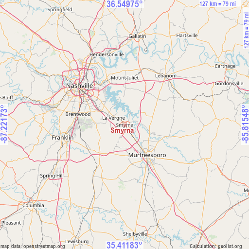
Smyrna GPS coordinates[2]
35° 58' 58.224" North, 86° 31' 6.96" West
| Map corner | latitude | longitude |
|---|---|---|
| Upper-left | 36.54975°, | -87.22173° |
| Center: | 35.98284°, | -86.5186° |
| Lower-right: | 35.41183°, | -85.81548° |
| Map W x H: | 126.5×126.5 km | = 78.6×78.6mi |
| max Lat: | 71.29058° ⇑70.5% North |
| Smyrna: | 35.98284° |
| min Lat: | ⇓29.5% South 19.06759° |
| min Long | Smyrna | max Long |
| -171.73463° | -86.5186° | -66.98998° |
| W 51.5%⇐ | ⇒48.5% E |
Elevation
Elevation of Smyrna is 167 m = 548 ft, and this is 127.8 m = 419 ft below average elevation for this country.
| Max E: |
3189 m = 10463 ft | 57.7% |
| Avg. | 294.8 m = 967 ft | |
| Smyrna | 167 m = 548 ft | |
Min E: |
-60 m = -197 ft | 42.3% |
See also: Smyrna elevation on elevation.city.
Geographical zone
Smyrna is located in North temperate zone (between Tropic of Cancer and the Arctic Circle). Distance of this Northern Tropic circle is 1395 km =866.8 mi to South.| Distance of | km | miles | from Smyrna |
|---|---|---|---|
| North Pole | 6006.1 | 3732 | to North |
| Arctic Circle | 3400.3 | 2112.8 | to North |
| Tropic Cancer | 1395 | 866.8 | to South |
| Equator | 4000.9 | 2486 | to South |


Nearby cities:
15 places around Smyrna: (largest is in red/bold)
• Berry Hill
26.8 km =16.7 mi,  303°
303°
• Brentwood
24.4 km =15.2 mi,  283°
283°
• Brentwood Estates
23.9 km =14.9 mi, 281°
• Christiana
32.2 km =20 mi,  160°
160°
• Eagleville
29.3 km =18.2 mi,  203°
203°
• Forest Hills
30.8 km =19.1 mi,  287°
287°
• Green Hill
26.8 km =16.7 mi,  354°
354°
• La Vergne
6.8 km =4.2 mi, 302°
• Lakewood
30.8 km =19.1 mi,  340°
340°
• Mount Juliet
24.2 km =15 mi,  359°
359°
• Murfreesboro
19.1 km =11.9 mi,  142°
142°
• Nashville
31.4 km =19.5 mi,  310°
310°
• Nolensville
14 km =8.7 mi,  255°
255°
• Oak Hill
26.5 km =16.5 mi, 296°
• Rural Hill
15.3 km =9.5 mi,  13°
13°
Sources, notices
• [Note1] Compared only with cities in United States existing in our database
• [Src1] Map data: © OpenStreetMap contributors (CC-BY-SA)
• [Src2] Other city data from geonames.org with taken over terms of usage.
• [Src3] Geographical zone / Annual Mean Temperature by Robert A. Rohde @ Wikipedia
