La Vergne geodata
La Vergne (Tennessee) is a populated place; located in United States in America/Chicago (GMT-5) time zone. With population of 34,794 people, there are 1412 cities with bigger population in this country. Compared to other cities in United States, 70.4% of cities are located further ↑North; 51.3% of cities are located further ←West and 55.3% of cities have higher elevation than La Vergne. Note1


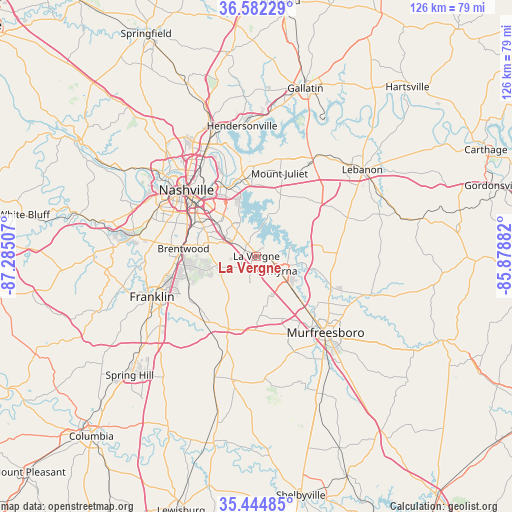
La Vergne GPS coordinates[2]
36° 0' 56.232" North, 86° 34' 54.984" West
| Map corner | latitude | longitude |
|---|---|---|
| Upper-left | 36.58229°, | -87.28507° |
| Center: | 36.01562°, | -86.58194° |
| Lower-right: | 35.44485°, | -85.87882° |
| Map W x H: | 126.5×126.5 km | = 78.6×78.6mi |
| max Lat: | 71.29058° ⇑70.4% North |
| La Vergne: | 36.01562° |
| min Lat: | ⇓29.6% South 19.06759° |
| min Long | La Vergne | max Long |
| -171.73463° | -86.58194° | -66.98998° |
| W 51.3%⇐ | ⇒48.7% E |
Elevation
Elevation of La Vergne is 179 m = 587 ft, and this is 115.8 m = 380 ft below average elevation for this country.
| Max E: |
3189 m = 10463 ft | 55.3% |
| Avg. | 294.8 m = 967 ft | |
| La Vergne | 179 m = 587 ft | |
Min E: |
-60 m = -197 ft | 44.7% |
See also: United States elevation on elevation.city.
Geographical zone
La Vergne is located in North temperate zone (between Tropic of Cancer and the Arctic Circle). Distance of this Northern Tropic circle is 1398.6 km =869 mi to South.| Distance of | km | miles | from La Vergne |
|---|---|---|---|
| North Pole | 6002.5 | 3729.8 | to North |
| Arctic Circle | 3396.6 | 2110.5 | to North |
| Tropic Cancer | 1398.6 | 869 | to South |
| Equator | 4004.6 | 2488.3 | to South |


Nearby cities:
15 places around La Vergne: (largest is in red/bold)
• Belle Meade
26.3 km =16.3 mi,  289°
289°
• Berry Hill
20 km =12.4 mi,  304°
304°
• Brentwood
18.2 km =11.3 mi,  276°
276°
• Brentwood Estates
17.8 km =11.1 mi,  273°
273°
• Forest Hills
24.3 km =15.1 mi, 283°
• Franklin
27.7 km =17.2 mi,  248°
248°
• Green Hill
23.2 km =14.4 mi,  7°
7°
• Lakewood
25.7 km =16 mi,  349°
349°
• Mount Juliet
21.3 km =13.2 mi,  15°
15°
• Murfreesboro
25.6 km =15.9 mi,  137°
137°
• Nashville
24.7 km =15.3 mi,  312°
312°
• Nolensville
10.6 km =6.6 mi,  228°
228°
• Oak Hill
19.8 km =12.3 mi, 293°
• Rural Hill
14.6 km =9.1 mi,  39°
39°
• Smyrna
6.8 km =4.2 mi,  122°
122°
Sources, notices
• [Note1] Compared only with cities in United States existing in our database
• [Src1] Map data: © OpenStreetMap contributors (CC-BY-SA)
• [Src2] Other city data from geonames.org with taken over terms of usage.
• [Src3] Geographical zone / Annual Mean Temperature by Robert A. Rohde @ Wikipedia
