Murfreesboro geodata
Murfreesboro (Tennessee) is a seat of a second-order administrative division; located in United States in America/Chicago (GMT-5) time zone. With population of 126,118 people, there are 250 cities with bigger population in this country. Compared to other cities in United States, 71.1% of cities are located further ↑North; 51.9% of cities are located further ←West and 51.9% of cities have higher elevation than Murfreesboro. Note1


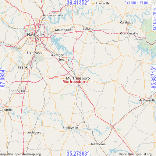
Murfreesboro GPS coordinates[2]
35° 50' 44.232" North, 86° 23' 24.972" West
| Map corner | latitude | longitude |
|---|---|---|
| Upper-left | 36.41352°, | -87.0934° |
| Center: | 35.84562°, | -86.39027° |
| Lower-right: | 35.27363°, | -85.68715° |
| Map W x H: | 126.7×126.7 km | = 78.7×78.7mi |
| max Lat: | 71.29058° ⇑71.1% North |
| Murfreesboro: | 35.84562° |
| min Lat: | ⇓28.9% South 19.06759° |
| min Long | Murfreesboro | max Long |
| -171.73463° | -86.39027° | -66.98998° |
| W 51.9%⇐ | ⇒48.1% E |
Elevation
Elevation of Murfreesboro is 191 m = 627 ft, and this is 103.8 m = 341 ft below average elevation for this country.
| Max E: |
3189 m = 10463 ft | 51.9% |
| Avg. | 294.8 m = 967 ft | |
| Murfreesboro | 191 m = 627 ft | |
Min E: |
-60 m = -197 ft | 48.1% |
See also: Murfreesboro elevation on elevation.city.
Geographical zone
Murfreesboro is located in North temperate zone (between Tropic of Cancer and the Arctic Circle). Distance of this Northern Tropic circle is 1379.7 km =857.3 mi to South.| Distance of | km | miles | from Murfreesboro |
|---|---|---|---|
| North Pole | 6021.4 | 3741.5 | to North |
| Arctic Circle | 3415.5 | 2122.3 | to North |
| Tropic Cancer | 1379.7 | 857.3 | to South |
| Equator | 3985.7 | 2476.6 | to South |


Nearby cities:
15 places around Murfreesboro: (largest is in red/bold)
• Bell Buckle
28.4 km =17.6 mi,  173°
173°
• Brentwood Estates
40.3 km =25 mi,  299°
299°
• Chapel Hill
36.6 km =22.7 mi,  228°
228°
• Christiana
15.1 km =9.4 mi,  183°
183°
• Eagleville
26.1 km =16.2 mi,  243°
243°
• La Vergne
25.6 km =15.9 mi,  317°
317°
• Lakewood Park
31.8 km =19.8 mi,  133°
133°
• Nolensville
27.8 km =17.3 mi, 295°
• Rural Hill
31.2 km =19.4 mi,  345°
345°
• Shelbyville
40.8 km =25.4 mi,  188°
188°
• Smyrna
19.1 km =11.9 mi, 322°
• Unionville
30.9 km =19.2 mi,  216°
216°
• Wartrace
35.8 km =22.2 mi, 171°
• Watertown
36.6 km =22.7 mi,  39°
39°
• Woodbury
28.8 km =17.9 mi,  93°
93°
Sources, notices
• [Note1] Compared only with cities in United States existing in our database
• [Src1] Map data: © OpenStreetMap contributors (CC-BY-SA)
• [Src2] Other city data from geonames.org with taken over terms of usage.
• [Src3] Geographical zone / Annual Mean Temperature by Robert A. Rohde @ Wikipedia
