Cornersville geodata
Cornersville (Tennessee) is a populated place; located in United States in America/Chicago (GMT-5) time zone. With population of 1,222 people, there are 15001 cities with bigger population in this country. Compared to other cities in United States, 73.4% of cities are located further ↑North; 50.7% of cities are located further ←West and 67% of cities have lower elevation than Cornersville. Note1


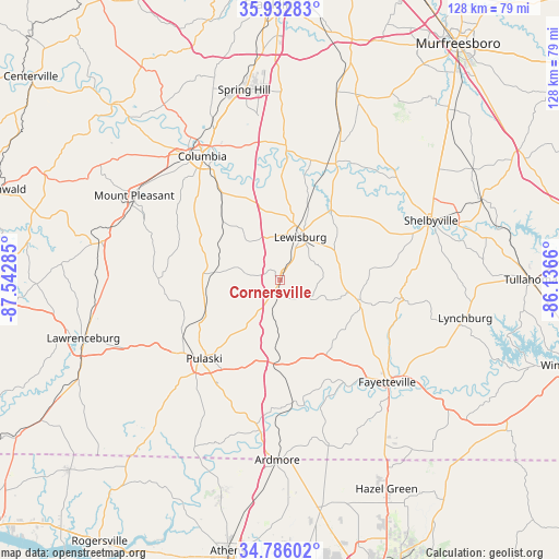
Cornersville GPS coordinates[2]
35° 21' 41.256" North, 86° 50' 22.992" West
| Map corner | latitude | longitude |
|---|---|---|
| Upper-left | 35.93283°, | -87.54285° |
| Center: | 35.36146°, | -86.83972° |
| Lower-right: | 34.78602°, | -86.1366° |
| Map W x H: | 127.5×127.5 km | = 79.2×79.2mi |
| max Lat: | 71.29058° ⇑73.4% North |
| Cornersville: | 35.36146° |
| min Lat: | ⇓26.6% South 19.06759° |
| min Long | Cornersville | max Long |
| -171.73463° | -86.83972° | -66.98998° |
| W 50.7%⇐ | ⇒49.3% E |
Elevation
Elevation of Cornersville is 271 m = 889 ft, and this is 23.8 m = 78 ft below average elevation for this country.
| Max E: |
3189 m = 10463 ft | 33% |
| Avg. | 294.8 m = 967 ft | |
| Cornersville | 271 m = 889 ft | |
Min E: |
-60 m = -197 ft | 67% |
See also: United States elevation on elevation.city.
Geographical zone
Cornersville is located in North temperate zone (between Tropic of Cancer and the Arctic Circle). Distance of this Northern Tropic circle is 1325.9 km =823.9 mi to South.| Distance of | km | miles | from Cornersville |
|---|---|---|---|
| North Pole | 6075.2 | 3775 | to North |
| Arctic Circle | 3469.3 | 2155.7 | to North |
| Tropic Cancer | 1325.9 | 823.9 | to South |
| Equator | 3931.8 | 2443.1 | to South |


Nearby cities:
15 places around Cornersville: (largest is in red/bold)
• Ardmore
41.1 km =25.5 mi,  180°
180°
• Chapel Hill
32.3 km =20.1 mi,  24°
24°
• Columbia
33.3 km =20.7 mi,  327°
327°
• Elkton
34.7 km =21.6 mi,  187°
187°
• Fayetteville
33.8 km =21 mi,  133°
133°
• Lewisburg
10.8 km =6.7 mi,  25°
25°
• Lynchburg
43.1 km =26.8 mi,  101°
101°
• Mount Pleasant
38.4 km =23.9 mi,  300°
300°
• Park City
39.5 km =24.5 mi,  141°
141°
• Petersburg
18.9 km =11.7 mi, 104°
• Pulaski
25 km =15.5 mi,  223°
223°
• Shelbyville
37 km =23 mi,  68°
68°
• Spring Hill
44.1 km =27.4 mi,  349°
349°
• Summertown
43.6 km =27.1 mi,  280°
280°
• Unionville
36.6 km =22.7 mi,  37°
37°
Sources, notices
• [Note1] Compared only with cities in United States existing in our database
• [Src1] Map data: © OpenStreetMap contributors (CC-BY-SA)
• [Src2] Other city data from geonames.org with taken over terms of usage.
• [Src3] Geographical zone / Annual Mean Temperature by Robert A. Rohde @ Wikipedia
