Summertown geodata
Summertown (Tennessee) is a populated place; located in United States in America/Chicago (GMT-5) time zone. With population of 866 people, there are 17228 cities with bigger population in this country. Compared to other cities in United States, 73% of cities are located further ↑North; 50.4% of cities are located further →East and 73.6% of cities have lower elevation than Summertown. Note1


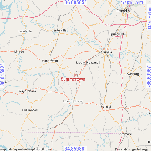
Summertown GPS coordinates[2]
35° 26' 5.28" North, 87° 18' 46.044" West
| Map corner | latitude | longitude |
|---|---|---|
| Upper-left | 36.00565°, | -88.01592° |
| Center: | 35.4348°, | -87.31279° |
| Lower-right: | 34.85988°, | -86.60967° |
| Map W x H: | 127.4×127.4 km | = 79.2×79.2mi |
| max Lat: | 71.29058° ⇑73% North |
| Summertown: | 35.4348° |
| min Lat: | ⇓27% South 19.06759° |
| min Long | Summertown | max Long |
| -171.73463° | -87.31279° | -66.98998° |
| W 49.6%⇐ | ⇒50.4% E |
Elevation
Elevation of Summertown is 305 m = 1001 ft, and this is 10.2 m = 33 ft above average elevation for this country.
| Max E: |
3189 m = 10463 ft | 26.4% |
| Summertown | 305 m 1001 ft | |
| Avg. | 294.8 m = 967 ft | |
Min E: |
-60 m = -197 ft | 73.6% |
See also: United States elevation on elevation.city.
Geographical zone
Summertown is located in North temperate zone (between Tropic of Cancer and the Arctic Circle). Distance of this Northern Tropic circle is 1334.1 km =829 mi to South.| Distance of | km | miles | from Summertown |
|---|---|---|---|
| North Pole | 6067.1 | 3769.9 | to North |
| Arctic Circle | 3461.2 | 2150.7 | to North |
| Tropic Cancer | 1334.1 | 829 | to South |
| Equator | 3940 | 2448.2 | to South |


Nearby cities:
15 places around Summertown: (largest is in red/bold)
• Centerville
40.7 km =25.3 mi,  339°
339°
• Collinwood
48.2 km =30 mi,  233°
233°
• Columbia
32.1 km =19.9 mi,  51°
51°
• Cornersville
43.6 km =27.1 mi,  100°
100°
• Hohenwald
25 km =15.5 mi,  300°
300°
• Lawrenceburg
21.5 km =13.4 mi,  185°
185°
• Lewisburg
47.5 km =29.5 mi,  88°
88°
• Linden
51.8 km =32.2 mi,  293°
293°
• Loretto
41.3 km =25.7 mi,  196°
196°
• Minor Hill
44.5 km =27.7 mi,  161°
161°
• Mount Pleasant
14.6 km =9.1 mi,  40°
40°
• Pulaski
36.6 km =22.7 mi,  135°
135°
• Saint Joseph
47.7 km =29.6 mi, 201°
• Spring Hill
49.3 km =30.6 mi, 44°
• Waynesboro
42.7 km =26.5 mi,  252°
252°
Sources, notices
• [Note1] Compared only with cities in United States existing in our database
• [Src1] Map data: © OpenStreetMap contributors (CC-BY-SA)
• [Src2] Other city data from geonames.org with taken over terms of usage.
• [Src3] Geographical zone / Annual Mean Temperature by Robert A. Rohde @ Wikipedia
