Dover geodata
Dover (Tennessee) is a seat of a second-order administrative division; located in United States in America/Chicago (GMT-5) time zone. With population of 1,457 people, there are 13850 cities with bigger population in this country. Compared to other cities in United States, 68.1% of cities are located further ↑North; 52.1% of cities are located further →East and 65% of cities have higher elevation than Dover. Note1


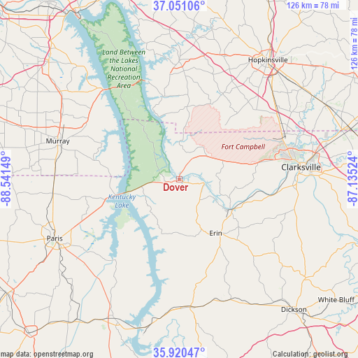
Dover GPS coordinates[2]
36° 29' 16.188" North, 87° 50' 18.096" West
| Map corner | latitude | longitude |
|---|---|---|
| Upper-left | 37.05106°, | -88.54149° |
| Center: | 36.48783°, | -87.83836° |
| Lower-right: | 35.92047°, | -87.13524° |
| Map W x H: | 125.7×125.7 km | = 78.1×78.1mi |
| max Lat: | 71.29058° ⇑68.1% North |
| Dover: | 36.48783° |
| min Lat: | ⇓31.9% South 19.06759° |
| min Long | Dover | max Long |
| -171.73463° | -87.83836° | -66.98998° |
| W 47.9%⇐ | ⇒52.1% E |
Elevation
Elevation of Dover is 128 m = 420 ft, and this is 166.8 m = 547 ft below average elevation for this country.
| Max E: |
3189 m = 10463 ft | 65% |
| Avg. | 294.8 m = 967 ft | |
| Dover | 128 m = 420 ft | |
Min E: |
-60 m = -197 ft | 35% |
See also: United States elevation on elevation.city.
Geographical zone
Dover is located in North temperate zone (between Tropic of Cancer and the Arctic Circle). Distance of this Northern Tropic circle is 1451.1 km =901.7 mi to South.| Distance of | km | miles | from Dover |
|---|---|---|---|
| North Pole | 5950 | 3697.2 | to North |
| Arctic Circle | 3344.1 | 2077.9 | to North |
| Tropic Cancer | 1451.1 | 901.7 | to South |
| Equator | 4057.1 | 2521 | to South |


Nearby cities:
15 places around Dover: (largest is in red/bold)
• Big Sandy
35.8 km =22.2 mi,  218°
218°
• Cadiz
41.9 km =26 mi,  0°
0°
• Clarksville
43.1 km =26.8 mi,  83°
83°
• Erin
22.8 km =14.2 mi,  145°
145°
• Fort Campbell North
38.5 km =23.9 mi,  61°
61°
• Hardin
51.1 km =31.8 mi,  307°
307°
• Johnsonville
48.7 km =30.3 mi,  192°
192°
• McEwen
46.1 km =28.6 mi,  156°
156°
• Murray
44.7 km =27.8 mi,  287°
287°
• Oak Grove
40.4 km =25.1 mi, 60°
• Paris
48.3 km =30 mi,  244°
244°
• Pleasant Hill
49.2 km =30.6 mi, 216°
• Puryear
44.6 km =27.7 mi,  263°
263°
• Tennessee Ridge
20.4 km =12.7 mi, 163°
• Waverly
45.1 km =28 mi,  175°
175°
Sources, notices
• [Note1] Compared only with cities in United States existing in our database
• [Src1] Map data: © OpenStreetMap contributors (CC-BY-SA)
• [Src2] Other city data from geonames.org with taken over terms of usage.
• [Src3] Geographical zone / Annual Mean Temperature by Robert A. Rohde @ Wikipedia
