Watertown geodata
Watertown (Tennessee) is a populated place; located in United States in America/Chicago (GMT-5) time zone. With population of 1,517 people, there are 13594 cities with bigger population in this country. Compared to other cities in United States, 70% of cities are located further ↑North; 52.5% of cities are located further ←West and 50% of cities have lower elevation than Watertown. Note1


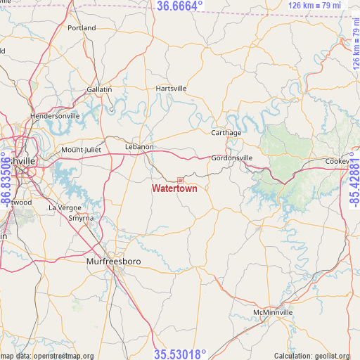
Watertown GPS coordinates[2]
36° 6' 1.224" North, 86° 7' 54.948" West
| Map corner | latitude | longitude |
|---|---|---|
| Upper-left | 36.6664°, | -86.83506° |
| Center: | 36.10034°, | -86.13193° |
| Lower-right: | 35.53018°, | -85.42881° |
| Map W x H: | 126.3×126.3 km | = 78.5×78.5mi |
| max Lat: | 71.29058° ⇑70% North |
| Watertown: | 36.10034° |
| min Lat: | ⇓30% South 19.06759° |
| min Long | Watertown | max Long |
| -171.73463° | -86.13193° | -66.98998° |
| W 52.5%⇐ | ⇒47.5% E |
Elevation
Elevation of Watertown is 198 m = 650 ft, and this is 96.8 m = 318 ft below average elevation for this country.
| Max E: |
3189 m = 10463 ft | 50% |
| Avg. | 294.8 m = 967 ft | |
| Watertown | 198 m = 650 ft | |
Min E: |
-60 m = -197 ft | 50% |
See also: United States elevation on elevation.city.
Geographical zone
Watertown is located in North temperate zone (between Tropic of Cancer and the Arctic Circle). Distance of this Northern Tropic circle is 1408.1 km =875 mi to South.| Distance of | km | miles | from Watertown |
|---|---|---|---|
| North Pole | 5993.1 | 3723.9 | to North |
| Arctic Circle | 3387.2 | 2104.7 | to North |
| Tropic Cancer | 1408.1 | 875 | to South |
| Equator | 4014 | 2494.2 | to South |


Nearby cities:
15 places around Watertown: (largest is in red/bold)
• Alexandria
9.2 km =5.7 mi,  105°
105°
• Carthage
23.4 km =14.5 mi,  43°
43°
• Castalian Springs
36.2 km =22.5 mi,  334°
334°
• Gordonsville
19.9 km =12.4 mi,  66°
66°
• Green Hill
39.9 km =24.8 mi,  289°
289°
• Hartsville
32.5 km =20.2 mi,  354°
354°
• Lafayette
38.5 km =23.9 mi,  75°
75°
• Lebanon
18.6 km =11.6 mi,  309°
309°
• Mount Juliet
36.4 km =22.6 mi, 287°
• Murfreesboro
36.6 km =22.7 mi,  219°
219°
• Rural Hill
31.2 km =19.4 mi,  273°
273°
• Smithville
32.5 km =20.2 mi,  118°
118°
• Smyrna
37.1 km =23.1 mi,  249°
249°
• South Carthage
22.6 km =14 mi,  45°
45°
• Woodbury
30.8 km =19.1 mi,  169°
169°
Sources, notices
• [Note1] Compared only with cities in United States existing in our database
• [Src1] Map data: © OpenStreetMap contributors (CC-BY-SA)
• [Src2] Other city data from geonames.org with taken over terms of usage.
• [Src3] Geographical zone / Annual Mean Temperature by Robert A. Rohde @ Wikipedia
