Germantown geodata
Germantown (Tennessee) is a populated place; located in United States in America/Chicago (GMT-5) time zone. With population of 39,240 people, there are 1239 cities with bigger population in this country. Compared to other cities in United States, 74.9% of cities are located further ↑North; 58.5% of cities are located further →East and 66.6% of cities have higher elevation than Germantown. Note1


Germantown GPS coordinates[2]
35° 5' 12.336" North, 89° 48' 36.324" West
| Map corner | latitude | longitude |
|---|---|---|
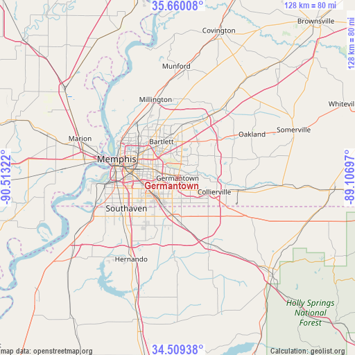
| Upper-left | 35.66008°, | -90.51322° |
| Center: | 35.08676°, | -89.81009° |
| Lower-right: | 34.50938°, | -89.10697° |
| Map W x H: | 127.9×127.9 km | = 79.5×79.5mi |
| max Lat: | 71.29058° ⇑74.9% North |
| Germantown: | 35.08676° |
| min Lat: | ⇓25.1% South 19.06759° |
| min Long | Germantown | max Long |
| -171.73463° | -89.81009° | -66.98998° |
| W 41.5%⇐ | ⇒58.5% E |
Elevation
Elevation of Germantown is 120 m = 394 ft, and this is 174.8 m = 573 ft below average elevation for this country.
| Max E: |
3189 m = 10463 ft | 66.6% |
| Avg. | 294.8 m = 967 ft | |
| Germantown | 120 m = 394 ft | |
Min E: |
-60 m = -197 ft | 33.4% |
See also: United States elevation on elevation.city.
Geographical zone
Germantown is located in North temperate zone (between Tropic of Cancer and the Arctic Circle). Distance of this Northern Tropic circle is 1295.4 km =804.9 mi to South.| Distance of | km | miles | from Germantown |
|---|---|---|---|
| North Pole | 6105.8 | 3794 | to North |
| Arctic Circle | 3499.9 | 2174.7 | to North |
| Tropic Cancer | 1295.4 | 804.9 | to South |
| Equator | 3901.3 | 2424.2 | to South |


Nearby cities:
15 places around Germantown: (largest is in red/bold)
• Arlington
26.9 km =16.7 mi,  30°
30°
• Bartlett
14.3 km =8.9 mi,  336°
336°
• Byhalia
26.2 km =16.3 mi,  155°
155°
• Collierville
14.1 km =8.8 mi,  110°
110°
• Hickory Withe
26.7 km =16.6 mi,  49°
49°
• Horn Lake
25.1 km =15.6 mi,  234°
234°
• Lakeland
17.2 km =10.7 mi,  21°
21°
• Lynchburg
29.5 km =18.3 mi,  242°
242°
• Memphis
22.8 km =14.2 mi,  287°
287°
• Millington
29.4 km =18.3 mi, 344°
• New South Memphis
22.4 km =13.9 mi,  270°
270°
• Olive Branch
14 km =8.7 mi,  187°
187°
• Piperton
17.8 km =11.1 mi, 105°
• Rossville
24.7 km =15.3 mi,  99°
99°
• Southaven
21.4 km =13.3 mi, 239°
Sources, notices
• [Note1] Compared only with cities in United States existing in our database
• [Src1] Map data: © OpenStreetMap contributors (CC-BY-SA)
• [Src2] Other city data from geonames.org with taken over terms of usage.
• [Src3] Geographical zone / Annual Mean Temperature by Robert A. Rohde @ Wikipedia
