Southaven geodata
Southaven (Mississippi) is a populated place; located in United States in America/Chicago (GMT-5) time zone. With population of 52,589 people, there are 888 cities with bigger population in this country. Compared to other cities in United States, 75.5% of cities are located further ↑North; 59% of cities are located further →East and 70.9% of cities have higher elevation than Southaven. Note1


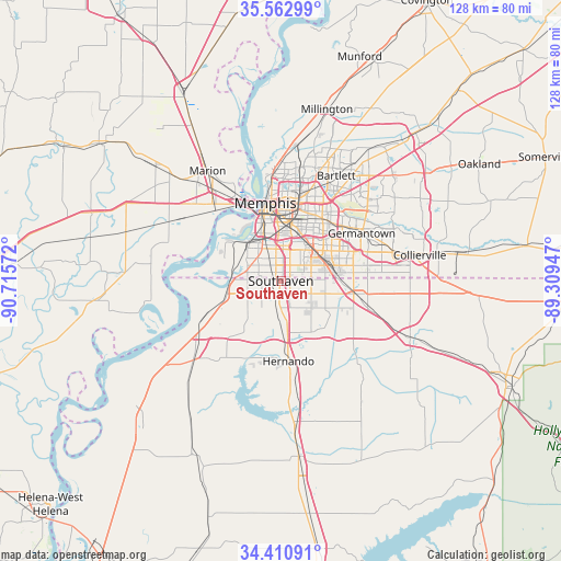
Southaven GPS coordinates[2]
34° 59' 20.328" North, 90° 0' 45.324" West
| Map corner | latitude | longitude |
|---|---|---|
| Upper-left | 35.56299°, | -90.71572° |
| Center: | 34.98898°, | -90.01259° |
| Lower-right: | 34.41091°, | -89.30947° |
| Map W x H: | 128.1×128.1 km | = 79.6×79.6mi |
| max Lat: | 71.29058° ⇑75.5% North |
| Southaven: | 34.98898° |
| min Lat: | ⇓24.5% South 19.06759° |
| min Long | Southaven | max Long |
| -171.73463° | -90.01259° | -66.98998° |
| W 41%⇐ | ⇒59% E |
Elevation
Elevation of Southaven is 95 m = 312 ft, and this is 199.8 m = 656 ft below average elevation for this country.
| Max E: |
3189 m = 10463 ft | 70.9% |
| Avg. | 294.8 m = 967 ft | |
| Southaven | 95 m = 312 ft | |
Min E: |
-60 m = -197 ft | 29.1% |
See also: Southaven elevation on elevation.city.
Geographical zone
Southaven is located in North temperate zone (between Tropic of Cancer and the Arctic Circle). Distance of this Northern Tropic circle is 1284.5 km =798.2 mi to South.| Distance of | km | miles | from Southaven |
|---|---|---|---|
| North Pole | 6116.7 | 3800.7 | to North |
| Arctic Circle | 3510.8 | 2181.5 | to North |
| Tropic Cancer | 1284.5 | 798.2 | to South |
| Equator | 3890.4 | 2417.4 | to South |


Nearby cities:
15 places around Southaven: (largest is in red/bold)
• Bartlett
27.1 km =16.8 mi,  27°
27°
• Byhalia
32.1 km =19.9 mi,  113°
113°
• Coldwater
33.2 km =20.6 mi,  174°
174°
• Collierville
32.2 km =20 mi,  79°
79°
• Germantown
21.4 km =13.3 mi,  59°
59°
• Hernando
18.4 km =11.4 mi, 174°
• Horn Lake
4.3 km =2.7 mi,  208°
208°
• Lynchburg
8.2 km =5.1 mi,  248°
248°
• Marion
30.1 km =18.7 mi,  326°
326°
• Memphis
18.2 km =11.3 mi,  349°
349°
• New South Memphis
11.6 km =7.2 mi,  339°
339°
• Olive Branch
17 km =10.6 mi,  100°
100°
• Tunica Resorts
34.9 km =21.7 mi,  240°
240°
• Walls
13.2 km =8.2 mi, 254°
• West Memphis
23.5 km =14.6 mi,  318°
318°
Sources, notices
• [Note1] Compared only with cities in United States existing in our database
• [Src1] Map data: © OpenStreetMap contributors (CC-BY-SA)
• [Src2] Other city data from geonames.org with taken over terms of usage.
• [Src3] Geographical zone / Annual Mean Temperature by Robert A. Rohde @ Wikipedia
