White Pine geodata
White Pine (Tennessee) is a populated place; located in United States in America/New_York (GMT-4) time zone. With population of 2,244 people, there are 11236 cities with bigger population in this country. Compared to other cities in United States, 69.9% of cities are located further ↑North; 61.2% of cities are located further ←West and 79.3% of cities have lower elevation than White Pine. Note1


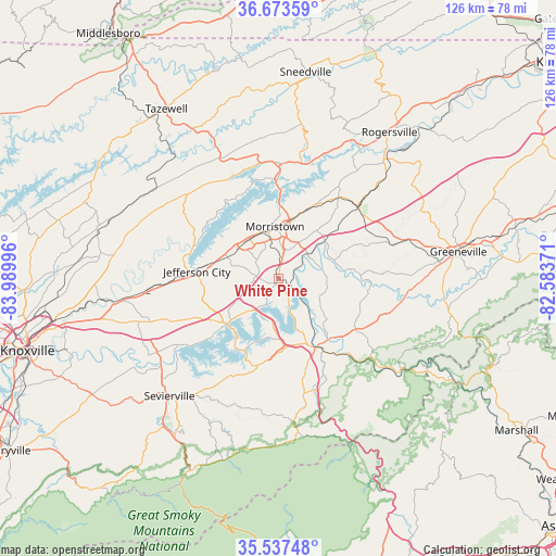
White Pine GPS coordinates[2]
36° 6' 27.324" North, 83° 17' 12.588" West
| Map corner | latitude | longitude |
|---|---|---|
| Upper-left | 36.67359°, | -83.98996° |
| Center: | 36.10759°, | -83.28683° |
| Lower-right: | 35.53748°, | -82.58371° |
| Map W x H: | 126.3×126.3 km | = 78.5×78.5mi |
| max Lat: | 71.29058° ⇑69.9% North |
| White Pine: | 36.10759° |
| min Lat: | ⇓30.1% South 19.06759° |
| min Long | White Pine | max Long |
| -171.73463° | -83.28683° | -66.98998° |
| W 61.2%⇐ | ⇒38.8% E |
Elevation
Elevation of White Pine is 347 m = 1138 ft, and this is 52.2 m = 171 ft above average elevation for this country.
| Max E: |
3189 m = 10463 ft | 20.7% |
| White Pine | 347 m 1138 ft | |
| Avg. | 294.8 m = 967 ft | |
Min E: |
-60 m = -197 ft | 79.3% |
See also: United States elevation on elevation.city.
Geographical zone
White Pine is located in North temperate zone (between Tropic of Cancer and the Arctic Circle). Distance of this Northern Tropic circle is 1408.9 km =875.4 mi to South.| Distance of | km | miles | from White Pine |
|---|---|---|---|
| North Pole | 5992.3 | 3723.4 | to North |
| Arctic Circle | 3386.4 | 2104.2 | to North |
| Tropic Cancer | 1408.9 | 875.4 | to South |
| Equator | 4014.8 | 2494.7 | to South |


Nearby cities:
15 places around White Pine: (largest is in red/bold)
• Bean Station
26.3 km =16.3 mi,  0°
0°
• Blaine
37.8 km =23.5 mi,  277°
277°
• Bulls Gap
24.5 km =15.2 mi,  47°
47°
• Dandridge
15.4 km =9.6 mi,  228°
228°
• Fair Garden
25.5 km =15.8 mi,  206°
206°
• Greeneville
41.4 km =25.7 mi,  81°
81°
• Jefferson City
18.5 km =11.5 mi, 275°
• Mooresburg
27.1 km =16.8 mi,  11°
11°
• Morristown
11.9 km =7.4 mi,  356°
356°
• Mosheim
30.9 km =19.2 mi,  72°
72°
• New Market
23.9 km =14.9 mi,  269°
269°
• Newport
18 km =11.2 mi,  150°
150°
• Pittman Center
40 km =24.9 mi,  194°
194°
• Rutledge
28.1 km =17.5 mi,  313°
313°
• Sevierville
36.3 km =22.6 mi,  222°
222°
Sources, notices
• [Note1] Compared only with cities in United States existing in our database
• [Src1] Map data: © OpenStreetMap contributors (CC-BY-SA)
• [Src2] Other city data from geonames.org with taken over terms of usage.
• [Src3] Geographical zone / Annual Mean Temperature by Robert A. Rohde @ Wikipedia
