Anderson geodata
Anderson (Texas) is a seat of a second-order administrative division; located in United States in America/Chicago (GMT-5) time zone. With population of 229 people, there are 21000 cities with bigger population in this country. Compared to other cities in United States, 91.9% of cities are located further ↑North; 73.4% of cities are located further →East and 68.5% of cities have higher elevation than Anderson. Note1


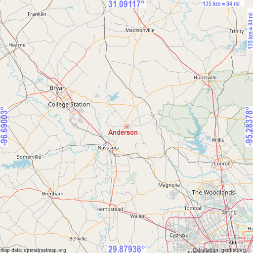
Anderson GPS coordinates[2]
30° 29' 13.74" North, 95° 59' 12.84" West
| Map corner | latitude | longitude |
|---|---|---|
| Upper-left | 31.09117°, | -96.69003° |
| Center: | 30.48715°, | -95.9869° |
| Lower-right: | 29.87936°, | -95.28378° |
| Map W x H: | 134.7×134.7 km | = 83.7×83.7mi |
| max Lat: | 71.29058° ⇑91.9% North |
| Anderson: | 30.48715° |
| min Lat: | ⇓8.1% South 19.06759° |
| min Long | Anderson | max Long |
| -171.73463° | -95.9869° | -66.98998° |
| W 26.6%⇐ | ⇒73.4% E |
Elevation
Elevation of Anderson is 110 m = 361 ft, and this is 184.8 m = 606 ft below average elevation for this country.
| Max E: |
3189 m = 10463 ft | 68.5% |
| Avg. | 294.8 m = 967 ft | |
| Anderson | 110 m = 361 ft | |
Min E: |
-60 m = -197 ft | 31.5% |
See also: United States elevation on elevation.city.
Geographical zone
Anderson is located in North temperate zone (between Tropic of Cancer and the Arctic Circle). Distance of this Northern Tropic circle is 783.9 km =487.1 mi to South.| Distance of | km | miles | from Anderson |
|---|---|---|---|
| North Pole | 6617.2 | 4111.7 | to North |
| Arctic Circle | 4011.3 | 2492.5 | to North |
| Tropic Cancer | 783.9 | 487.1 | to South |
| Equator | 3389.9 | 2106.4 | to South |


Nearby cities:
15 places around Anderson: (largest is in red/bold)
• Bryan
42.2 km =26.2 mi,  299°
299°
• College Station
36.8 km =22.9 mi, 295°
• Hempstead
44.2 km =27.5 mi,  191°
191°
• Magnolia
38.3 km =23.8 mi,  143°
143°
• Montgomery
29.9 km =18.6 mi,  111°
111°
• Navasota
14.7 km =9.1 mi,  221°
221°
• New Waverly
48.6 km =30.2 mi,  83°
83°
• Panorama Village
48.7 km =30.3 mi,  104°
104°
• Pine Island
48 km =29.8 mi, 185°
• Pinehurst
45.7 km =28.4 mi, 140°
• Prairie View
43.8 km =27.2 mi,  180°
180°
• Snook
45.8 km =28.5 mi,  270°
270°
• Stagecoach
46.2 km =28.7 mi,  145°
145°
• Waller
48.2 km =30 mi,  173°
173°
• Willis
49.1 km =30.5 mi, 98°
Sources, notices
• [Note1] Compared only with cities in United States existing in our database
• [Src1] Map data: © OpenStreetMap contributors (CC-BY-SA)
• [Src2] Other city data from geonames.org with taken over terms of usage.
• [Src3] Geographical zone / Annual Mean Temperature by Robert A. Rohde @ Wikipedia
