Montgomery geodata
Montgomery (Texas) is a populated place; located in United States in America/Chicago (GMT-5) time zone. With population of 806 people, there are 17758 cities with bigger population in this country. Compared to other cities in United States, 92.2% of cities are located further ↑North; 72.8% of cities are located further →East and 71.5% of cities have higher elevation than Montgomery. Note1


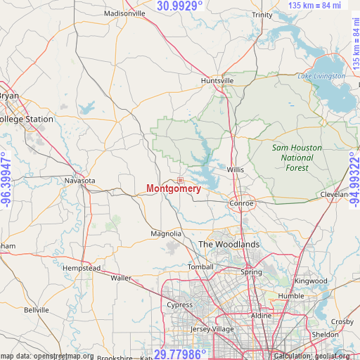
Montgomery GPS coordinates[2]
30° 23' 17.736" North, 95° 41' 46.824" West
| Map corner | latitude | longitude |
|---|---|---|
| Upper-left | 30.9929°, | -96.39947° |
| Center: | 30.38826°, | -95.69634° |
| Lower-right: | 29.77986°, | -94.99322° |
| Map W x H: | 134.9×134.9 km | = 83.8×83.8mi |
| max Lat: | 71.29058° ⇑92.2% North |
| Montgomery: | 30.38826° |
| min Lat: | ⇓7.8% South 19.06759° |
| min Long | Montgomery | max Long |
| -171.73463° | -95.69634° | -66.98998° |
| W 27.2%⇐ | ⇒72.8% E |
Elevation
Elevation of Montgomery is 92 m = 302 ft, and this is 202.8 m = 665 ft below average elevation for this country.
| Max E: |
3189 m = 10463 ft | 71.5% |
| Avg. | 294.8 m = 967 ft | |
| Montgomery | 92 m = 302 ft | |
Min E: |
-60 m = -197 ft | 28.5% |
See also: United States elevation on elevation.city.
Geographical zone
Montgomery is located in North temperate zone (between Tropic of Cancer and the Arctic Circle). Distance of this Northern Tropic circle is 772.9 km =480.3 mi to South.| Distance of | km | miles | from Montgomery |
|---|---|---|---|
| North Pole | 6628.2 | 4118.6 | to North |
| Arctic Circle | 4022.3 | 2499.3 | to North |
| Tropic Cancer | 772.9 | 480.3 | to South |
| Equator | 3378.9 | 2099.6 | to South |


Nearby cities:
15 places around Montgomery: (largest is in red/bold)
• Anderson
29.9 km =18.6 mi,  291°
291°
• Conroe
24.6 km =15.3 mi,  110°
110°
• Cut and Shoot
33 km =20.5 mi,  100°
100°
• Huntsville
39.8 km =24.7 mi,  20°
20°
• Magnolia
20.6 km =12.8 mi,  194°
194°
• Navasota
37.5 km =23.3 mi,  269°
269°
• New Waverly
26.3 km =16.3 mi,  50°
50°
• Oak Ridge North
35 km =21.7 mi,  136°
136°
• Panorama Village
19.5 km =12.1 mi,  92°
92°
• Pinehurst
24.2 km =15 mi,  176°
176°
• Shenandoah
32.7 km =20.3 mi, 135°
• Stagecoach
27 km =16.8 mi, 183°
• The Woodlands
32.4 km =20.1 mi, 142°
• Tomball
33.3 km =20.7 mi,  166°
166°
• Willis
21.1 km =13.1 mi,  78°
78°
Sources, notices
• [Note1] Compared only with cities in United States existing in our database
• [Src1] Map data: © OpenStreetMap contributors (CC-BY-SA)
• [Src2] Other city data from geonames.org with taken over terms of usage.
• [Src3] Geographical zone / Annual Mean Temperature by Robert A. Rohde @ Wikipedia
