Manor geodata
Manor (Texas) is a populated place; located in United States in America/Chicago (GMT-5) time zone. With population of 7,587 people, there are 5488 cities with bigger population in this country. Compared to other cities in United States, 92.4% of cities are located further ↑North; 77.3% of cities are located further →East and 58% of cities have higher elevation than Manor. Note1


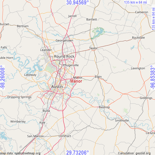
Manor GPS coordinates[2]
30° 20' 26.736" North, 97° 33' 25.02" West
| Map corner | latitude | longitude |
|---|---|---|
| Upper-left | 30.94569°, | -98.26008° |
| Center: | 30.34076°, | -97.55695° |
| Lower-right: | 29.73206°, | -96.85383° |
| Map W x H: | 134.9×134.9 km | = 83.8×83.8mi |
| max Lat: | 71.29058° ⇑92.4% North |
| Manor: | 30.34076° |
| min Lat: | ⇓7.6% South 19.06759° |
| min Long | Manor | max Long |
| -171.73463° | -97.55695° | -66.98998° |
| W 22.7%⇐ | ⇒77.3% E |
Elevation
Elevation of Manor is 165 m = 541 ft, and this is 129.8 m = 426 ft below average elevation for this country.
| Max E: |
3189 m = 10463 ft | 58% |
| Avg. | 294.8 m = 967 ft | |
| Manor | 165 m = 541 ft | |
Min E: |
-60 m = -197 ft | 42% |
See also: United States elevation on elevation.city.
Geographical zone
Manor is located in North temperate zone (between Tropic of Cancer and the Arctic Circle). Distance of this Northern Tropic circle is 767.7 km =477 mi to South.| Distance of | km | miles | from Manor |
|---|---|---|---|
| North Pole | 6633.5 | 4121.9 | to North |
| Arctic Circle | 4027.6 | 2502.6 | to North |
| Tropic Cancer | 767.7 | 477 | to South |
| Equator | 3373.6 | 2096.3 | to South |


Nearby cities:
15 places around Manor: (largest is in red/bold)
• Austin
19.7 km =12.2 mi,  245°
245°
• Brushy Creek
26 km =16.2 mi,  317°
317°
• Elgin
17.9 km =11.1 mi,  86°
86°
• Garfield
17 km =10.6 mi,  180°
180°
• Hornsby Bend
10.7 km =6.6 mi,  193°
193°
• Hutto
22.5 km =14 mi,  2°
2°
• Jollyville
23.8 km =14.8 mi,  298°
298°
• Pflugerville
12.5 km =7.8 mi,  331°
331°
• Rollingwood
23.6 km =14.7 mi, 252°
• Round Rock
22 km =13.7 mi, 327°
• Sunset Valley
26.9 km =16.7 mi,  241°
241°
• Wells Branch
16.6 km =10.3 mi,  314°
314°
• West Lake Hills
24 km =14.9 mi,  258°
258°
• Windemere
15.9 km =9.9 mi, 326°
• Wyldwood
24.9 km =15.5 mi,  161°
161°
Sources, notices
• [Note1] Compared only with cities in United States existing in our database
• [Src1] Map data: © OpenStreetMap contributors (CC-BY-SA)
• [Src2] Other city data from geonames.org with taken over terms of usage.
• [Src3] Geographical zone / Annual Mean Temperature by Robert A. Rohde @ Wikipedia
