Woodcreek geodata
Woodcreek (Texas) is a populated place; located in United States in America/Chicago (GMT-5) time zone. With population of 1,528 people, there are 13556 cities with bigger population in this country. Compared to other cities in United States, 93.3% of cities are located further ↑North; 78.7% of cities are located further →East and 72.9% of cities have lower elevation than Woodcreek. Note1


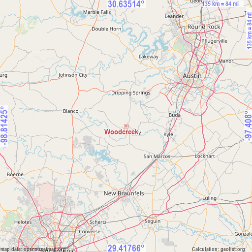
Woodcreek GPS coordinates[2]
30° 1' 41.772" North, 98° 6' 40.032" West
| Map corner | latitude | longitude |
|---|---|---|
| Upper-left | 30.63514°, | -98.81425° |
| Center: | 30.02827°, | -98.11112° |
| Lower-right: | 29.41766°, | -97.408° |
| Map W x H: | 135.4×135.4 km | = 84.1×84.1mi |
| max Lat: | 71.29058° ⇑93.3% North |
| Woodcreek: | 30.02827° |
| min Lat: | ⇓6.7% South 19.06759° |
| min Long | Woodcreek | max Long |
| -171.73463° | -98.11112° | -66.98998° |
| W 21.3%⇐ | ⇒78.7% E |
Elevation
Elevation of Woodcreek is 301 m = 988 ft, and this is 6.2 m = 20 ft above average elevation for this country.
| Max E: |
3189 m = 10463 ft | 27.1% |
| Woodcreek | 301 m 988 ft | |
| Avg. | 294.8 m = 967 ft | |
Min E: |
-60 m = -197 ft | 72.9% |
See also: United States elevation on elevation.city.
Geographical zone
Woodcreek is located in North temperate zone (between Tropic of Cancer and the Arctic Circle). Distance of this Northern Tropic circle is 732.9 km =455.4 mi to South.| Distance of | km | miles | from Woodcreek |
|---|---|---|---|
| North Pole | 6668.2 | 4143.4 | to North |
| Arctic Circle | 4062.3 | 2524.2 | to North |
| Tropic Cancer | 732.9 | 455.4 | to South |
| Equator | 3338.8 | 2074.6 | to South |


Nearby cities:
15 places around Woodcreek: (largest is in red/bold)
• Blanco
30.8 km =19.1 mi,  284°
284°
• Buda
26.8 km =16.7 mi,  76°
76°
• Canyon Lake
22.4 km =13.9 mi,  220°
220°
• Dripping Springs
18.2 km =11.3 mi,  7°
7°
• Kyle
22.9 km =14.2 mi,  100°
100°
• Manchaca
29.5 km =18.3 mi,  64°
64°
• Martindale
33 km =20.5 mi,  127°
127°
• Mountain City
21.6 km =13.4 mi,  87°
87°
• Onion Creek
33.7 km =20.9 mi,  69°
69°
• Redwood
31 km =19.3 mi,  141°
141°
• San Leanna
31.1 km =19.3 mi, 65°
• San Marcos
23 km =14.3 mi, 134°
• Shady Hollow
28.4 km =17.6 mi, 57°
• Uhland
32.3 km =20.1 mi, 104°
• Wimberley
3.6 km =2.2 mi,  160°
160°
Sources, notices
• [Note1] Compared only with cities in United States existing in our database
• [Src1] Map data: © OpenStreetMap contributors (CC-BY-SA)
• [Src2] Other city data from geonames.org with taken over terms of usage.
• [Src3] Geographical zone / Annual Mean Temperature by Robert A. Rohde @ Wikipedia
