Gainesville geodata
Gainesville (Texas) is a seat of a second-order administrative division; located in United States in America/Chicago (GMT-5) time zone. With population of 16,292 people, there are 3018 cities with bigger population in this country. Compared to other cities in United States, 82.5% of cities are located further ↑North; 76.1% of cities are located further →East and 58.6% of cities have lower elevation than Gainesville. Note1


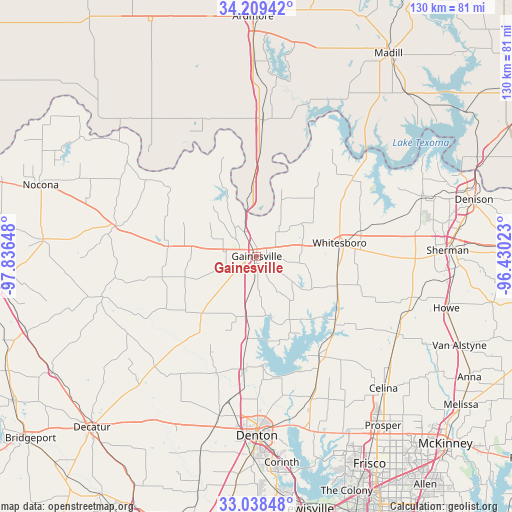
Gainesville GPS coordinates[2]
33° 37' 33.384" North, 97° 8' 0.06" West
| Map corner | latitude | longitude |
|---|---|---|
| Upper-left | 34.20942°, | -97.83648° |
| Center: | 33.62594°, | -97.13335° |
| Lower-right: | 33.03848°, | -96.43023° |
| Map W x H: | 130.2×130.2 km | = 80.9×80.9mi |
| max Lat: | 71.29058° ⇑82.5% North |
| Gainesville: | 33.62594° |
| min Lat: | ⇓17.5% South 19.06759° |
| min Long | Gainesville | max Long |
| -171.73463° | -97.13335° | -66.98998° |
| W 23.9%⇐ | ⇒76.1% E |
Elevation
Elevation of Gainesville is 233 m = 764 ft, and this is 61.8 m = 203 ft below average elevation for this country.
| Max E: |
3189 m = 10463 ft | 41.4% |
| Avg. | 294.8 m = 967 ft | |
| Gainesville | 233 m = 764 ft | |
Min E: |
-60 m = -197 ft | 58.6% |
See also: United States elevation on elevation.city.
Geographical zone
Gainesville is located in North temperate zone (between Tropic of Cancer and the Arctic Circle). Distance of this Northern Tropic circle is 1132.9 km =704 mi to South.| Distance of | km | miles | from Gainesville |
|---|---|---|---|
| North Pole | 6268.2 | 3894.9 | to North |
| Arctic Circle | 3662.3 | 2275.6 | to North |
| Tropic Cancer | 1132.9 | 704 | to South |
| Equator | 3738.9 | 2323.2 | to South |


Nearby cities:
15 places around Gainesville: (largest is in red/bold)
• Aubrey
38.3 km =23.8 mi,  159°
159°
• Collinsville
21.8 km =13.5 mi,  109°
109°
• Krugerville
40.5 km =25.2 mi, 160°
• Lake Kiowa
12.4 km =7.7 mi,  116°
116°
• Lindsay
8.4 km =5.2 mi,  277°
277°
• Marietta
34.6 km =21.5 mi,  2°
2°
• Muenster
22.7 km =14.1 mi, 277°
• Pilot Point
30.1 km =18.7 mi,  147°
147°
• Saint Jo
36.8 km =22.9 mi, 282°
• Sanger
29.5 km =18.3 mi,  187°
187°
• Sherwood Shores
38.5 km =23.9 mi,  49°
49°
• Southmayd
33.7 km =20.9 mi,  89°
89°
• Tioga
26.6 km =16.5 mi,  131°
131°
• Valley View
15.6 km =9.7 mi, 190°
• Whitesboro
21.2 km =13.2 mi,  80°
80°
Sources, notices
• [Note1] Compared only with cities in United States existing in our database
• [Src1] Map data: © OpenStreetMap contributors (CC-BY-SA)
• [Src2] Other city data from geonames.org with taken over terms of usage.
• [Src3] Geographical zone / Annual Mean Temperature by Robert A. Rohde @ Wikipedia
