Lake Kiowa geodata
Lake Kiowa (Texas) is a populated place; located in United States in America/Chicago (GMT-5) time zone. With population of 1,906 people, there are 12210 cities with bigger population in this country. Compared to other cities in United States, 82.8% of cities are located further ↑North; 75.8% of cities are located further →East and 54.9% of cities have lower elevation than Lake Kiowa. Note1


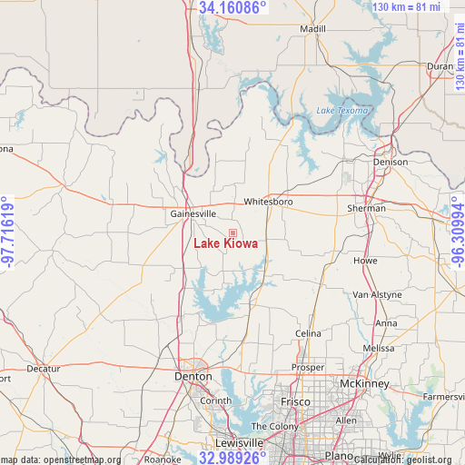
Lake Kiowa GPS coordinates[2]
33° 34' 37.38" North, 97° 0' 47.016" West
| Map corner | latitude | longitude |
|---|---|---|
| Upper-left | 34.16086°, | -97.71619° |
| Center: | 33.57705°, | -97.01306° |
| Lower-right: | 32.98926°, | -96.30994° |
| Map W x H: | 130.3×130.3 km | = 81×81mi |
| max Lat: | 71.29058° ⇑82.8% North |
| Lake Kiowa: | 33.57705° |
| min Lat: | ⇓17.2% South 19.06759° |
| min Long | Lake Kiowa | max Long |
| -171.73463° | -97.01306° | -66.98998° |
| W 24.2%⇐ | ⇒75.8% E |
Elevation
Elevation of Lake Kiowa is 218 m = 715 ft, and this is 76.8 m = 252 ft below average elevation for this country.
| Max E: |
3189 m = 10463 ft | 45.1% |
| Avg. | 294.8 m = 967 ft | |
| Lake Kiowa | 218 m = 715 ft | |
Min E: |
-60 m = -197 ft | 54.9% |
See also: United States elevation on elevation.city.
Geographical zone
Lake Kiowa is located in North temperate zone (between Tropic of Cancer and the Arctic Circle). Distance of this Northern Tropic circle is 1127.5 km =700.6 mi to South.| Distance of | km | miles | from Lake Kiowa |
|---|---|---|---|
| North Pole | 6273.6 | 3898.2 | to North |
| Arctic Circle | 3667.8 | 2279.1 | to North |
| Tropic Cancer | 1127.5 | 700.6 | to South |
| Equator | 3733.4 | 2319.8 | to South |


Nearby cities:
15 places around Lake Kiowa: (largest is in red/bold)
• Aubrey
30.4 km =18.9 mi,  175°
175°
• Celina
35.2 km =21.9 mi,  142°
142°
• Collinsville
9.6 km =6 mi,  100°
100°
• Gainesville
12.4 km =7.7 mi,  296°
296°
• Gunter
28.5 km =17.7 mi,  120°
120°
• Krugerville
32.9 km =20.4 mi, 176°
• Lindsay
20.5 km =12.7 mi,  288°
288°
• Muenster
34.7 km =21.6 mi,  283°
283°
• Pilot Point
20.7 km =12.9 mi,  166°
166°
• Sanger
28.1 km =17.5 mi,  212°
212°
• Sherwood Shores
35.5 km =22.1 mi,  30°
30°
• Southmayd
23.4 km =14.5 mi,  75°
75°
• Tioga
15.1 km =9.4 mi, 144°
• Valley View
17.2 km =10.7 mi,  234°
234°
• Whitesboro
13.2 km =8.2 mi,  48°
48°
Sources, notices
• [Note1] Compared only with cities in United States existing in our database
• [Src1] Map data: © OpenStreetMap contributors (CC-BY-SA)
• [Src2] Other city data from geonames.org with taken over terms of usage.
• [Src3] Geographical zone / Annual Mean Temperature by Robert A. Rohde @ Wikipedia
