Eldorado geodata
Eldorado (Texas) is a seat of a second-order administrative division; located in United States in America/Chicago (GMT-5) time zone. With population of 1,810 people, there are 12509 cities with bigger population in this country. Compared to other cities in United States, 91% of cities are located further ↑North; 81.1% of cities are located further →East and 91.4% of cities have lower elevation than Eldorado. Note1


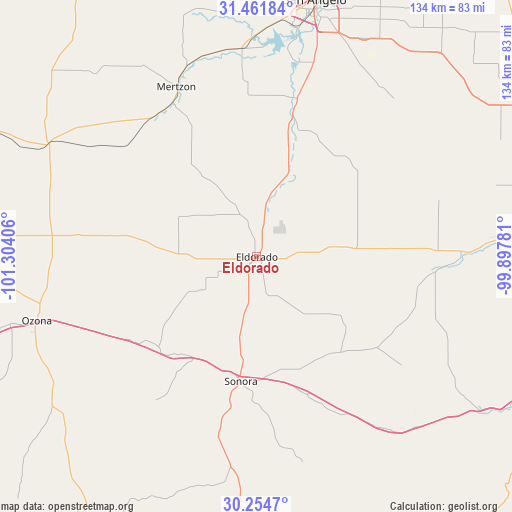
Eldorado GPS coordinates[2]
30° 51' 36.612" North, 100° 36' 3.348" West
| Map corner | latitude | longitude |
|---|---|---|
| Upper-left | 31.46184°, | -101.30406° |
| Center: | 30.86017°, | -100.60093° |
| Lower-right: | 30.2547°, | -99.89781° |
| Map W x H: | 134.2×134.2 km | = 83.4×83.4mi |
| max Lat: | 71.29058° ⇑91% North |
| Eldorado: | 30.86017° |
| min Lat: | ⇓9% South 19.06759° |
| min Long | Eldorado | max Long |
| -171.73463° | -100.60093° | -66.98998° |
| W 18.9%⇐ | ⇒81.1% E |
Elevation
Elevation of Eldorado is 746 m = 2448 ft, and this is 451.2 m = 1480 ft above average elevation for this country.
| Max E: |
3189 m = 10463 ft | 8.6% |
| Eldorado | 746 m 2448 ft | |
| Avg. | 294.8 m = 967 ft | |
Min E: |
-60 m = -197 ft | 91.4% |
See also: United States elevation on elevation.city.
Geographical zone
Eldorado is located in North temperate zone (between Tropic of Cancer and the Arctic Circle). Distance of this Northern Tropic circle is 825.4 km =512.9 mi to South.| Distance of | km | miles | from Eldorado |
|---|---|---|---|
| North Pole | 6575.7 | 4085.9 | to North |
| Arctic Circle | 3969.8 | 2466.7 | to North |
| Tropic Cancer | 825.4 | 512.9 | to South |
| Equator | 3431.3 | 2132.1 | to South |


Nearby cities:
15 places around Eldorado: (largest is in red/bold)
• Big Lake
89.8 km =55.8 mi,  294°
294°
• Carlsbad
83 km =51.6 mi,  357°
357°
• Christoval
38.3 km =23.8 mi,  14°
14°
• Eden
82.1 km =51 mi,  61°
61°
• Grape Creek
80.1 km =49.8 mi,  3°
3°
• Junction
89.4 km =55.6 mi,  117°
117°
• Menard
78 km =48.5 mi,  85°
85°
• Mertzon
49.2 km =30.6 mi,  335°
335°
• Miles
91.1 km =56.6 mi,  25°
25°
• Ozona
59.7 km =37.1 mi,  253°
253°
• Paint Rock
96.9 km =60.2 mi,  41°
41°
• Rocksprings
101.3 km =62.9 mi,  158°
158°
• San Angelo
68.9 km =42.8 mi, 13°
• Sonora
32.9 km =20.4 mi,  187°
187°
• Sterling City
114.5 km =71.1 mi, 341°
Sources, notices
• [Note1] Compared only with cities in United States existing in our database
• [Src1] Map data: © OpenStreetMap contributors (CC-BY-SA)
• [Src2] Other city data from geonames.org with taken over terms of usage.
• [Src3] Geographical zone / Annual Mean Temperature by Robert A. Rohde @ Wikipedia
