Kempner geodata
Kempner (Texas) is a populated place; located in United States in America/Chicago (GMT-5) time zone. With population of 1,078 people, there are 15797 cities with bigger population in this country. Compared to other cities in United States, 90.6% of cities are located further ↑North; 78.5% of cities are located further →East and 66.6% of cities have lower elevation than Kempner. Note1


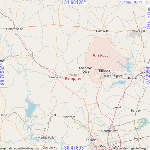
Kempner GPS coordinates[2]
31° 4' 51.636" North, 98° 0' 9.072" West
| Map corner | latitude | longitude |
|---|---|---|
| Upper-left | 31.68128°, | -98.70565° |
| Center: | 31.08101°, | -98.00252° |
| Lower-right: | 30.47693°, | -97.2994° |
| Map W x H: | 133.9×133.9 km | = 83.2×83.2mi |
| max Lat: | 71.29058° ⇑90.6% North |
| Kempner: | 31.08101° |
| min Lat: | ⇓9.4% South 19.06759° |
| min Long | Kempner | max Long |
| -171.73463° | -98.00252° | -66.98998° |
| W 21.5%⇐ | ⇒78.5% E |
Elevation
Elevation of Kempner is 269 m = 883 ft, and this is 25.8 m = 85 ft below average elevation for this country.
| Max E: |
3189 m = 10463 ft | 33.4% |
| Avg. | 294.8 m = 967 ft | |
| Kempner | 269 m = 883 ft | |
Min E: |
-60 m = -197 ft | 66.6% |
See also: United States elevation on elevation.city.
Geographical zone
Kempner is located in North temperate zone (between Tropic of Cancer and the Arctic Circle). Distance of this Northern Tropic circle is 850 km =528.2 mi to South.| Distance of | km | miles | from Kempner |
|---|---|---|---|
| North Pole | 6551.2 | 4070.7 | to North |
| Arctic Circle | 3945.3 | 2451.5 | to North |
| Tropic Cancer | 850 | 528.2 | to South |
| Equator | 3455.9 | 2147.4 | to South |


Nearby cities:
15 places around Kempner: (largest is in red/bold)
• Bertram
37.8 km =23.5 mi,  187°
187°
• Burnet
41.9 km =26 mi,  210°
210°
• Copperas Cove
10.6 km =6.6 mi,  63°
63°
• Florence
33.3 km =20.7 mi,  143°
143°
• Fort Gates
45.2 km =28.1 mi,  38°
38°
• Fort Hood
22.4 km =13.9 mi,  74°
74°
• Gatesville
46.4 km =28.8 mi,  31°
31°
• Harker Heights
32.6 km =20.3 mi,  89°
89°
• Jarrell
47.5 km =29.5 mi,  126°
126°
• Killeen
26.5 km =16.5 mi,  81°
81°
• Lampasas
17.2 km =10.7 mi,  263°
263°
• Liberty Hill
46.9 km =29.1 mi,  170°
170°
• Lometa
40.2 km =25 mi,  292°
292°
• Nolanville
37.8 km =23.5 mi, 90°
• Salado
46.6 km =29 mi,  108°
108°
Sources, notices
• [Note1] Compared only with cities in United States existing in our database
• [Src1] Map data: © OpenStreetMap contributors (CC-BY-SA)
• [Src2] Other city data from geonames.org with taken over terms of usage.
• [Src3] Geographical zone / Annual Mean Temperature by Robert A. Rohde @ Wikipedia
