Fort Hood geodata
Fort Hood (Texas) is a populated place; located in United States in America/Chicago (GMT-5) time zone. With population of 29,589 people, there are 1686 cities with bigger population in this country. Compared to other cities in United States, 90.5% of cities are located further ↑North; 77.9% of cities are located further →East and 68% of cities have lower elevation than Fort Hood. Note1


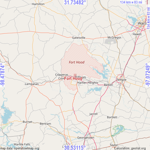
Fort Hood GPS coordinates[2]
31° 8' 5.604" North, 97° 46' 32.196" West
| Map corner | latitude | longitude |
|---|---|---|
| Upper-left | 31.73482°, | -98.47874° |
| Center: | 31.13489°, | -97.77561° |
| Lower-right: | 30.53115°, | -97.07249° |
| Map W x H: | 133.8×133.8 km | = 83.1×83.1mi |
| max Lat: | 71.29058° ⇑90.5% North |
| Fort Hood: | 31.13489° |
| min Lat: | ⇓9.5% South 19.06759° |
| min Long | Fort Hood | max Long |
| -171.73463° | -97.77561° | -66.98998° |
| W 22.1%⇐ | ⇒77.9% E |
Elevation
Elevation of Fort Hood is 276 m = 906 ft, and this is 18.8 m = 62 ft below average elevation for this country.
| Max E: |
3189 m = 10463 ft | 32% |
| Avg. | 294.8 m = 967 ft | |
| Fort Hood | 276 m = 906 ft | |
Min E: |
-60 m = -197 ft | 68% |
See also: United States elevation on elevation.city.
Geographical zone
Fort Hood is located in North temperate zone (between Tropic of Cancer and the Arctic Circle). Distance of this Northern Tropic circle is 856 km =531.9 mi to South.| Distance of | km | miles | from Fort Hood |
|---|---|---|---|
| North Pole | 6545.2 | 4067 | to North |
| Arctic Circle | 3939.3 | 2447.8 | to North |
| Tropic Cancer | 856 | 531.9 | to South |
| Equator | 3461.9 | 2151.1 | to South |


Nearby cities:
15 places around Fort Hood: (largest is in red/bold)
• Ames
42.9 km =26.7 mi,  359°
359°
• Belton
30.9 km =19.2 mi,  106°
106°
• Copperas Cove
12.2 km =7.6 mi,  264°
264°
• Florence
32.7 km =20.3 mi,  183°
183°
• Fort Gates
30.1 km =18.7 mi,  12°
12°
• Gatesville
33.5 km =20.8 mi, 5°
• Harker Heights
12.4 km =7.7 mi,  117°
117°
• Jarrell
38.1 km =23.7 mi,  154°
154°
• Kempner
22.4 km =13.9 mi,  254°
254°
• Killeen
5 km =3.1 mi, 113°
• Lampasas
39.5 km =24.5 mi, 258°
• Morgans Point Resort
29.8 km =18.5 mi,  87°
87°
• Nolanville
17.3 km =10.7 mi, 111°
• Salado
30.8 km =19.1 mi,  132°
132°
• Temple
41.4 km =25.7 mi,  95°
95°
Sources, notices
• [Note1] Compared only with cities in United States existing in our database
• [Src1] Map data: © OpenStreetMap contributors (CC-BY-SA)
• [Src2] Other city data from geonames.org with taken over terms of usage.
• [Src3] Geographical zone / Annual Mean Temperature by Robert A. Rohde @ Wikipedia
