Wyldwood geodata
Wyldwood (Texas) is a populated place; located in United States in America/Chicago (GMT-5) time zone. With population of 2,505 people, there are 10601 cities with bigger population in this country. Compared to other cities in United States, 93% of cities are located further ↑North; 77.1% of cities are located further →East and 58.8% of cities have higher elevation than Wyldwood. Note1


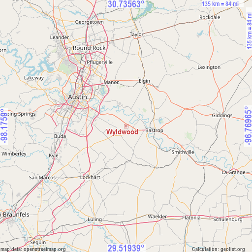
Wyldwood GPS coordinates[2]
30° 7' 45.768" North, 97° 28' 21.972" West
| Map corner | latitude | longitude |
|---|---|---|
| Upper-left | 30.73563°, | -98.1759° |
| Center: | 30.12938°, | -97.47277° |
| Lower-right: | 29.51939°, | -96.76965° |
| Map W x H: | 135.2×135.2 km | = 84×84mi |
| max Lat: | 71.29058° ⇑93% North |
| Wyldwood: | 30.12938° |
| min Lat: | ⇓7% South 19.06759° |
| min Long | Wyldwood | max Long |
| -171.73463° | -97.47277° | -66.98998° |
| W 22.9%⇐ | ⇒77.1% E |
Elevation
Elevation of Wyldwood is 161 m = 528 ft, and this is 133.8 m = 439 ft below average elevation for this country.
| Max E: |
3189 m = 10463 ft | 58.8% |
| Avg. | 294.8 m = 967 ft | |
| Wyldwood | 161 m = 528 ft | |
Min E: |
-60 m = -197 ft | 41.2% |
See also: United States elevation on elevation.city.
Geographical zone
Wyldwood is located in North temperate zone (between Tropic of Cancer and the Arctic Circle). Distance of this Northern Tropic circle is 744.2 km =462.4 mi to South.| Distance of | km | miles | from Wyldwood |
|---|---|---|---|
| North Pole | 6657 | 4136.5 | to North |
| Arctic Circle | 4051.1 | 2517.2 | to North |
| Tropic Cancer | 744.2 | 462.4 | to South |
| Equator | 3350.1 | 2081.7 | to South |


Nearby cities:
15 places around Wyldwood: (largest is in red/bold)
• Austin
30.2 km =18.8 mi,  300°
300°
• Bastrop
15.3 km =9.5 mi,  97°
97°
• Camp Swift
18.7 km =11.6 mi,  68°
68°
• Circle D-KC Estates
23.2 km =14.4 mi,  81°
81°
• Elgin
26.4 km =16.4 mi,  21°
21°
• Garfield
10.4 km =6.5 mi,  308°
308°
• Hornsby Bend
16.9 km =10.5 mi,  321°
321°
• Lockhart
33.2 km =20.6 mi,  214°
214°
• Manor
24.9 km =15.5 mi,  341°
341°
• McDade
28.4 km =17.6 mi,  52°
52°
• Mustang Ridge
22.5 km =14 mi,  249°
249°
• Niederwald
28 km =17.4 mi,  241°
241°
• Onion Creek
30 km =18.6 mi,  271°
271°
• San Leanna
33.3 km =20.7 mi, 273°
• Smithville
33 km =20.5 mi,  114°
114°
Sources, notices
• [Note1] Compared only with cities in United States existing in our database
• [Src1] Map data: © OpenStreetMap contributors (CC-BY-SA)
• [Src2] Other city data from geonames.org with taken over terms of usage.
• [Src3] Geographical zone / Annual Mean Temperature by Robert A. Rohde @ Wikipedia
