Zavalla geodata
Zavalla (Texas) is a populated place; located in United States in America/Chicago (GMT-5) time zone. With population of 715 people, there are 18550 cities with bigger population in this country. Compared to other cities in United States, 90.4% of cities are located further ↑North; 69.7% of cities are located further →East and 74.9% of cities have higher elevation than Zavalla. Note1


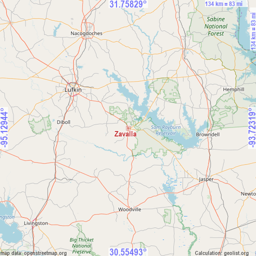
Zavalla GPS coordinates[2]
31° 9' 30.672" North, 94° 25' 34.716" West
| Map corner | latitude | longitude |
|---|---|---|
| Upper-left | 31.75829°, | -95.12944° |
| Center: | 31.15852°, | -94.42631° |
| Lower-right: | 30.55493°, | -93.72319° |
| Map W x H: | 133.8×133.8 km | = 83.1×83.1mi |
| max Lat: | 71.29058° ⇑90.4% North |
| Zavalla: | 31.15852° |
| min Lat: | ⇓9.6% South 19.06759° |
| min Long | Zavalla | max Long |
| -171.73463° | -94.42631° | -66.98998° |
| W 30.3%⇐ | ⇒69.7% E |
Elevation
Elevation of Zavalla is 72 m = 236 ft, and this is 222.8 m = 731 ft below average elevation for this country.
| Max E: |
3189 m = 10463 ft | 74.9% |
| Avg. | 294.8 m = 967 ft | |
| Zavalla | 72 m = 236 ft | |
Min E: |
-60 m = -197 ft | 25.1% |
See also: United States elevation on elevation.city.
Geographical zone
Zavalla is located in North temperate zone (between Tropic of Cancer and the Arctic Circle). Distance of this Northern Tropic circle is 858.6 km =533.5 mi to South.| Distance of | km | miles | from Zavalla |
|---|---|---|---|
| North Pole | 6542.6 | 4065.4 | to North |
| Arctic Circle | 3936.7 | 2446.2 | to North |
| Tropic Cancer | 858.6 | 533.5 | to South |
| Equator | 3464.5 | 2152.7 | to South |


Nearby cities:
15 places around Zavalla: (largest is in red/bold)
• Burke
33.6 km =20.9 mi,  284°
284°
• Colmesneil
27.9 km =17.3 mi,  179°
179°
• Corrigan
42.2 km =26.2 mi,  244°
244°
• Diboll
33.9 km =21.1 mi, 275°
• Hudson
38.1 km =23.7 mi,  298°
298°
• Huntington
19.5 km =12.1 mi,  312°
312°
• Jasper
48.8 km =30.3 mi,  122°
122°
• Lufkin
35 km =21.7 mi, 304°
• Nacogdoches
54 km =33.6 mi,  336°
336°
• Pineland
44.1 km =27.4 mi,  76°
76°
• Pleasant Hill
39.1 km =24.3 mi, 244°
• Redland
39.2 km =24.4 mi, 314°
• Sam Rayburn
38.6 km =24 mi,  105°
105°
• San Augustine
51.3 km =31.9 mi,  36°
36°
• Woodville
42.6 km =26.5 mi, 178°
Sources, notices
• [Note1] Compared only with cities in United States existing in our database
• [Src1] Map data: © OpenStreetMap contributors (CC-BY-SA)
• [Src2] Other city data from geonames.org with taken over terms of usage.
• [Src3] Geographical zone / Annual Mean Temperature by Robert A. Rohde @ Wikipedia
