Mansfield geodata
Mansfield (Texas) is a populated place; located in United States in America/Chicago (GMT-5) time zone. With population of 64,274 people, there are 673 cities with bigger population in this country. Compared to other cities in United States, 86.9% of cities are located further ↑North; 76.1% of cities are located further →East and 52.8% of cities have higher elevation than Mansfield. Note1


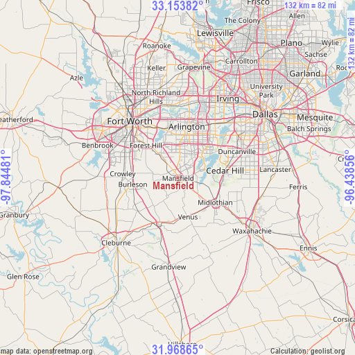
Mansfield GPS coordinates[2]
32° 33' 47.484" North, 97° 8' 30.048" West
| Map corner | latitude | longitude |
|---|---|---|
| Upper-left | 33.15382°, | -97.84481° |
| Center: | 32.56319°, | -97.14168° |
| Lower-right: | 31.96865°, | -96.43856° |
| Map W x H: | 131.8×131.8 km | = 81.9×81.9mi |
| max Lat: | 71.29058° ⇑86.9% North |
| Mansfield: | 32.56319° |
| min Lat: | ⇓13.1% South 19.06759° |
| min Long | Mansfield | max Long |
| -171.73463° | -97.14168° | -66.98998° |
| W 23.9%⇐ | ⇒76.1% E |
Elevation
Elevation of Mansfield is 188 m = 617 ft, and this is 106.8 m = 350 ft below average elevation for this country.
| Max E: |
3189 m = 10463 ft | 52.8% |
| Avg. | 294.8 m = 967 ft | |
| Mansfield | 188 m = 617 ft | |
Min E: |
-60 m = -197 ft | 47.2% |
See also: Mansfield elevation on elevation.city.
Geographical zone
Mansfield is located in North temperate zone (between Tropic of Cancer and the Arctic Circle). Distance of this Northern Tropic circle is 1014.8 km =630.6 mi to South.| Distance of | km | miles | from Mansfield |
|---|---|---|---|
| North Pole | 6386.4 | 3968.3 | to North |
| Arctic Circle | 3780.5 | 2349.1 | to North |
| Tropic Cancer | 1014.8 | 630.6 | to South |
| Equator | 3620.7 | 2249.8 | to South |


Nearby cities:
15 places around Mansfield: (largest is in red/bold)
• Alvarado
18.6 km =11.6 mi,  200°
200°
• Arlington
19.4 km =12.1 mi,  9°
9°
• Burleson
17 km =10.6 mi,  262°
262°
• Cedar Hill
17.6 km =10.9 mi,  80°
80°
• Crowley
20.8 km =12.9 mi,  274°
274°
• Dalworthington Gardens
15.6 km =9.7 mi,  355°
355°
• Duncanville
24 km =14.9 mi,  65°
65°
• Edgecliff Village
21.6 km =13.4 mi,  299°
299°
• Everman
15.7 km =9.8 mi, 298°
• Forest Hill
17 km =10.6 mi,  315°
315°
• Kennedale
12.2 km =7.6 mi, 319°
• Midlothian
16.5 km =10.3 mi,  123°
123°
• Pantego
16.9 km =10.5 mi, 355°
• Rendon
9.5 km =5.9 mi,  278°
278°
• Venus
14.9 km =9.3 mi,  165°
165°
Sources, notices
• [Note1] Compared only with cities in United States existing in our database
• [Src1] Map data: © OpenStreetMap contributors (CC-BY-SA)
• [Src2] Other city data from geonames.org with taken over terms of usage.
• [Src3] Geographical zone / Annual Mean Temperature by Robert A. Rohde @ Wikipedia
