Winters geodata
Winters (Texas) is a populated place; located in United States in America/Chicago (GMT-5) time zone. With population of 2,563 people, there are 10472 cities with bigger population in this country. Compared to other cities in United States, 88.7% of cities are located further ↑North; 80.8% of cities are located further →East and 89% of cities have lower elevation than Winters. Note1


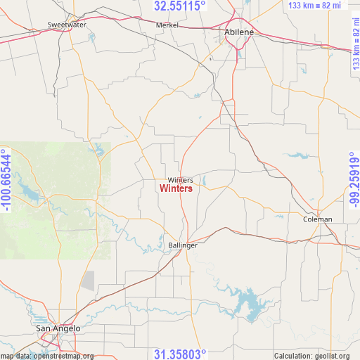
Winters GPS coordinates[2]
31° 57' 23.508" North, 99° 57' 44.316" West
| Map corner | latitude | longitude |
|---|---|---|
| Upper-left | 32.55115°, | -100.66544° |
| Center: | 31.95653°, | -99.96231° |
| Lower-right: | 31.35803°, | -99.25919° |
| Map W x H: | 132.7×132.7 km | = 82.5×82.5mi |
| max Lat: | 71.29058° ⇑88.7% North |
| Winters: | 31.95653° |
| min Lat: | ⇓11.3% South 19.06759° |
| min Long | Winters | max Long |
| -171.73463° | -99.96231° | -66.98998° |
| W 19.2%⇐ | ⇒80.8% E |
Elevation
Elevation of Winters is 564 m = 1850 ft, and this is 269.2 m = 883 ft above average elevation for this country.
| Max E: |
3189 m = 10463 ft | 11% |
| Winters | 564 m 1850 ft | |
| Avg. | 294.8 m = 967 ft | |
Min E: |
-60 m = -197 ft | 89% |
See also: United States elevation on elevation.city.
Geographical zone
Winters is located in North temperate zone (between Tropic of Cancer and the Arctic Circle). Distance of this Northern Tropic circle is 947.3 km =588.6 mi to South.| Distance of | km | miles | from Winters |
|---|---|---|---|
| North Pole | 6453.8 | 4010.2 | to North |
| Arctic Circle | 3847.9 | 2391 | to North |
| Tropic Cancer | 947.3 | 588.6 | to South |
| Equator | 3553.2 | 2207.9 | to South |


Nearby cities:
15 places around Winters: (largest is in red/bold)
• Abilene
58.8 km =36.5 mi,  21°
21°
• Ballinger
24.3 km =15.1 mi,  176°
176°
• Bronte
32 km =19.9 mi,  256°
256°
• Clyde
66.6 km =41.4 mi,  41°
41°
• Coleman
52.6 km =32.7 mi,  105°
105°
• Grape Creek
69.4 km =43.1 mi,  232°
232°
• Merkel
57.4 km =35.7 mi,  355°
355°
• Miles
45 km =28 mi,  207°
207°
• Paint Rock
50 km =31.1 mi, 175°
• Potosi
50.5 km =31.4 mi,  34°
34°
• Robert Lee
49.8 km =30.9 mi, 261°
• San Angelo
70.8 km =44 mi,  219°
219°
• Santa Anna
65 km =40.4 mi, 111°
• Tuscola
32.2 km =20 mi, 29°
• Tye
56.4 km =35 mi,  8°
8°
Sources, notices
• [Note1] Compared only with cities in United States existing in our database
• [Src1] Map data: © OpenStreetMap contributors (CC-BY-SA)
• [Src2] Other city data from geonames.org with taken over terms of usage.
• [Src3] Geographical zone / Annual Mean Temperature by Robert A. Rohde @ Wikipedia
