Grape Creek geodata
Grape Creek (Texas) is a populated place; located in United States in America/Chicago (GMT-5) time zone. With population of 3,154 people, there are 9369 cities with bigger population in this country. Compared to other cities in United States, 89.5% of cities are located further ↑North; 81.1% of cities are located further →East and 89.7% of cities have lower elevation than Grape Creek. Note1


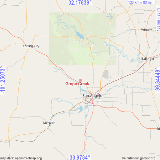
Grape Creek GPS coordinates[2]
31° 34' 45.552" North, 100° 32' 51.36" West
| Map corner | latitude | longitude |
|---|---|---|
| Upper-left | 32.17639°, | -101.25073° |
| Center: | 31.57932°, | -100.5476° |
| Lower-right: | 30.9784°, | -99.84448° |
| Map W x H: | 133.2×133.2 km | = 82.8×82.8mi |
| max Lat: | 71.29058° ⇑89.5% North |
| Grape Creek: | 31.57932° |
| min Lat: | ⇓10.5% South 19.06759° |
| min Long | Grape Creek | max Long |
| -171.73463° | -100.5476° | -66.98998° |
| W 18.9%⇐ | ⇒81.1% E |
Elevation
Elevation of Grape Creek is 607 m = 1991 ft, and this is 312.2 m = 1024 ft above average elevation for this country.
| Max E: |
3189 m = 10463 ft | 10.3% |
| Grape Creek | 607 m 1991 ft | |
| Avg. | 294.8 m = 967 ft | |
Min E: |
-60 m = -197 ft | 89.7% |
See also: United States elevation on elevation.city.
Geographical zone
Grape Creek is located in North temperate zone (between Tropic of Cancer and the Arctic Circle). Distance of this Northern Tropic circle is 905.4 km =562.6 mi to South.| Distance of | km | miles | from Grape Creek |
|---|---|---|---|
| North Pole | 6495.8 | 4036.3 | to North |
| Arctic Circle | 3889.9 | 2417.1 | to North |
| Tropic Cancer | 905.4 | 562.6 | to South |
| Equator | 3511.3 | 2181.8 | to South |


Nearby cities:
15 places around Grape Creek: (largest is in red/bold)
• Ballinger
59.5 km =37 mi,  72°
72°
• Bronte
41.9 km =26 mi,  35°
35°
• Carlsbad
9.5 km =5.9 mi,  287°
287°
• Christoval
43.1 km =26.8 mi,  173°
173°
• Eden
77.9 km =48.4 mi,  121°
121°
• Eldorado
80.1 km =49.8 mi,  183°
183°
• Garden City
93.8 km =58.3 mi, 289°
• Loraine
93.8 km =58.3 mi,  350°
350°
• Mertzon
43.6 km =27.1 mi,  215°
215°
• Miles
34.7 km =21.6 mi,  86°
86°
• Paint Rock
60 km =37.3 mi,  97°
97°
• Robert Lee
35.3 km =21.9 mi,  9°
9°
• San Angelo
16.6 km =10.3 mi,  140°
140°
• Sterling City
50.3 km =31.3 mi,  304°
304°
• Winters
69.4 km =43.1 mi,  52°
52°
Sources, notices
• [Note1] Compared only with cities in United States existing in our database
• [Src1] Map data: © OpenStreetMap contributors (CC-BY-SA)
• [Src2] Other city data from geonames.org with taken over terms of usage.
• [Src3] Geographical zone / Annual Mean Temperature by Robert A. Rohde @ Wikipedia
