San Angelo geodata
San Angelo (Texas) is a seat of a second-order administrative division; located in United States in America/Chicago (GMT-5) time zone. With population of 100,450 people, there are 347 cities with bigger population in this country. Compared to other cities in United States, 89.7% of cities are located further ↑North; 81% of cities are located further →East and 89% of cities have lower elevation than San Angelo. Note1


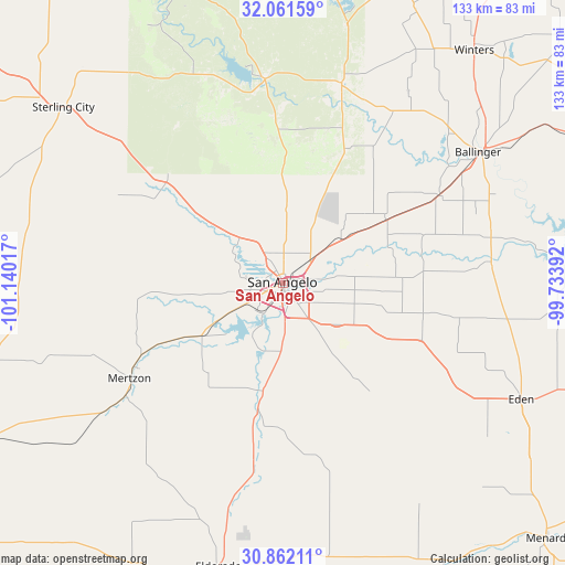
San Angelo GPS coordinates[2]
31° 27' 49.572" North, 100° 26' 13.344" West
| Map corner | latitude | longitude |
|---|---|---|
| Upper-left | 32.06159°, | -101.14017° |
| Center: | 31.46377°, | -100.43704° |
| Lower-right: | 30.86211°, | -99.73392° |
| Map W x H: | 133.4×133.4 km | = 82.9×82.9mi |
| max Lat: | 71.29058° ⇑89.7% North |
| San Angelo: | 31.46377° |
| min Lat: | ⇓10.3% South 19.06759° |
| min Long | San Angelo | max Long |
| -171.73463° | -100.43704° | -66.98998° |
| W 19%⇐ | ⇒81% E |
Elevation
Elevation of San Angelo is 564 m = 1850 ft, and this is 269.2 m = 883 ft above average elevation for this country.
| Max E: |
3189 m = 10463 ft | 11% |
| San Angelo | 564 m 1850 ft | |
| Avg. | 294.8 m = 967 ft | |
Min E: |
-60 m = -197 ft | 89% |
See also: San Angelo elevation on elevation.city.
Geographical zone
San Angelo is located in North temperate zone (between Tropic of Cancer and the Arctic Circle). Distance of this Northern Tropic circle is 892.5 km =554.6 mi to South.| Distance of | km | miles | from San Angelo |
|---|---|---|---|
| North Pole | 6508.6 | 4044.3 | to North |
| Arctic Circle | 3902.7 | 2425 | to North |
| Tropic Cancer | 892.5 | 554.6 | to South |
| Equator | 3498.4 | 2173.8 | to South |


Nearby cities:
15 places around San Angelo: (largest is in red/bold)
• Ballinger
55.5 km =34.5 mi,  56°
56°
• Bronte
49.1 km =30.5 mi,  16°
16°
• Carlsbad
25.1 km =15.6 mi,  308°
308°
• Christoval
30.6 km =19 mi,  191°
191°
• Eden
62.5 km =38.8 mi,  116°
116°
• Eldorado
68.9 km =42.8 mi, 193°
• Grape Creek
16.6 km =10.3 mi,  320°
320°
• Menard
86.7 km =53.9 mi,  134°
134°
• Mertzon
42.5 km =26.4 mi,  238°
238°
• Miles
28.3 km =17.6 mi, 58°
• Paint Rock
49.3 km =30.6 mi,  84°
84°
• Robert Lee
47.9 km =29.8 mi,  354°
354°
• Sonora
101.6 km =63.1 mi, 191°
• Sterling City
66.4 km =41.3 mi, 308°
• Winters
70.8 km =44 mi,  39°
39°
Sources, notices
• [Note1] Compared only with cities in United States existing in our database
• [Src1] Map data: © OpenStreetMap contributors (CC-BY-SA)
• [Src2] Other city data from geonames.org with taken over terms of usage.
• [Src3] Geographical zone / Annual Mean Temperature by Robert A. Rohde @ Wikipedia
