Woodville geodata
Woodville (Texas) is a seat of a second-order administrative division; located in United States in America/Chicago (GMT-5) time zone. With population of 2,478 people, there are 10678 cities with bigger population in this country. Compared to other cities in United States, 91.1% of cities are located further ↑North; 69.7% of cities are located further →East and 72.5% of cities have higher elevation than Woodville. Note1


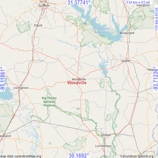
Woodville GPS coordinates[2]
30° 46' 30.72" North, 94° 24' 55.728" West
| Map corner | latitude | longitude |
|---|---|---|
| Upper-left | 31.37741°, | -95.11861° |
| Center: | 30.7752°, | -94.41548° |
| Lower-right: | 30.1692°, | -93.71236° |
| Map W x H: | 134.3×134.3 km | = 83.5×83.5mi |
| max Lat: | 71.29058° ⇑91.1% North |
| Woodville: | 30.7752° |
| min Lat: | ⇓8.9% South 19.06759° |
| min Long | Woodville | max Long |
| -171.73463° | -94.41548° | -66.98998° |
| W 30.3%⇐ | ⇒69.7% E |
Elevation
Elevation of Woodville is 86 m = 282 ft, and this is 208.8 m = 685 ft below average elevation for this country.
| Max E: |
3189 m = 10463 ft | 72.5% |
| Avg. | 294.8 m = 967 ft | |
| Woodville | 86 m = 282 ft | |
Min E: |
-60 m = -197 ft | 27.5% |
See also: United States elevation on elevation.city.
Geographical zone
Woodville is located in North temperate zone (between Tropic of Cancer and the Arctic Circle). Distance of this Northern Tropic circle is 816 km =507 mi to South.| Distance of | km | miles | from Woodville |
|---|---|---|---|
| North Pole | 6585.2 | 4091.9 | to North |
| Arctic Circle | 3979.3 | 2472.6 | to North |
| Tropic Cancer | 816 | 507 | to South |
| Equator | 3421.9 | 2126.3 | to South |


Nearby cities:
15 places around Woodville: (largest is in red/bold)
• Colmesneil
14.8 km =9.2 mi,  357°
357°
• Corrigan
46.4 km =28.8 mi,  302°
302°
• Evadale
57.1 km =35.5 mi,  144°
144°
• Indian Springs
33.4 km =20.8 mi,  254°
254°
• Jasper
43.1 km =26.8 mi,  68°
68°
• Kirbyville
51.6 km =32.1 mi,  104°
104°
• Kountze
45.9 km =28.5 mi,  167°
167°
• Livingston
50 km =31.1 mi,  261°
261°
• Pleasant Hill
44.8 km =27.8 mi,  305°
305°
• Sam Rayburn
48.4 km =30.1 mi,  48°
48°
• Silsbee
52.6 km =32.7 mi,  154°
154°
• Warren
17.9 km =11.1 mi,  177°
177°
• West Livingston
56.7 km =35.2 mi, 261°
• Wildwood
28 km =17.4 mi,  185°
185°
• Zavalla
42.6 km =26.5 mi, 358°
Sources, notices
• [Note1] Compared only with cities in United States existing in our database
• [Src1] Map data: © OpenStreetMap contributors (CC-BY-SA)
• [Src2] Other city data from geonames.org with taken over terms of usage.
• [Src3] Geographical zone / Annual Mean Temperature by Robert A. Rohde @ Wikipedia
